Late ancient fort "Kastra Martis"
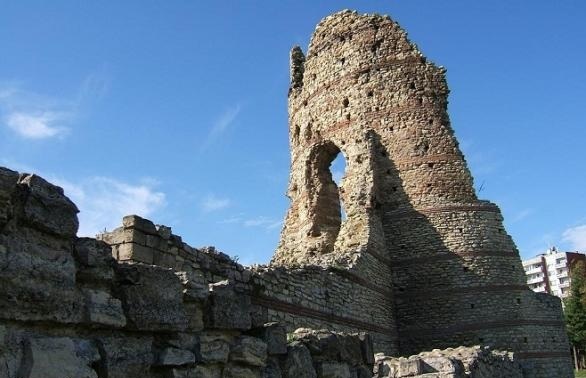
Kastra Martis is a late Ancient fort whose remains are situated in the very center of the town of Kula, Vidin Region. It is located at 33 km south-west of Vidin, 56 km north-west of Belogradchik, 215 km north of the capital Sofia city and about 15 km of the national border with Serbia.
The fort is situated on the steep southern slope above the gorge of Voynishka River. The first person to have explored these places is the Hungarian archaeologist Felix Kanitz in the 70s of XIX century. During archaeological researches it was discovered that this slope used to be a small Thracian-Roman settlement from the first millennium BC before the construction of the castle.
The fortress is part of the restored Danube limes of the Roman Empire after the loss of Dacia in the late III century. The fort was most probably built by Emperor Diocletian at the border between III and IV century. It was used to defend the way from Bononia to Singidunum through Vrashka chuka - one of the western passes of the Balkan Mountains. In V century Procopius of Caesarea mentions Castra Martis as one of the main strongholds restored by the Emperor Justinian I (527-565). Castra Martis was destroyed by when the Avars invaded the empire from 586 to 587. In the XIII - XIV century the fort was partly restored and was used for the defense of the Vidin Kingdom.
architecture
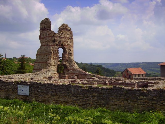
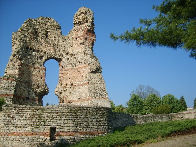
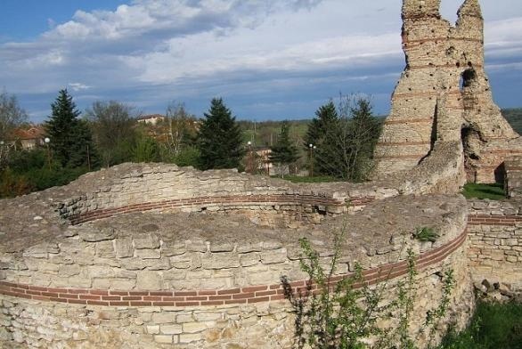
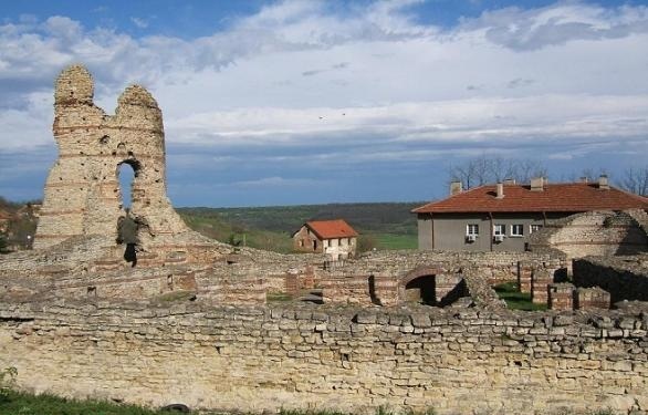
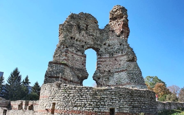
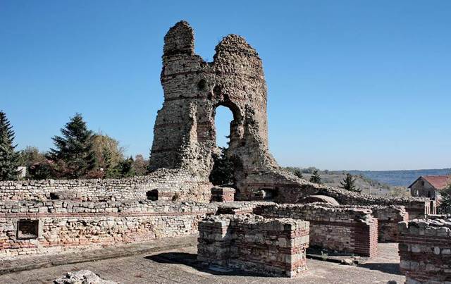
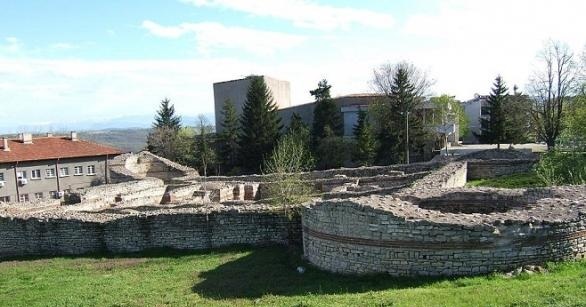
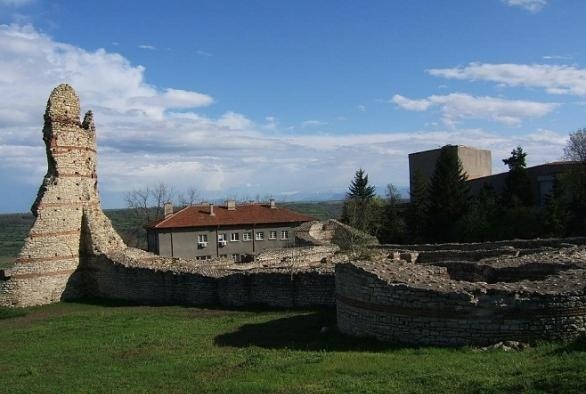
Studies show that the fortress comprises two parts - a quadriburgius and a castle. Both parts were not designed and implemented simultaneously. The quadriburgius was built first - at the end of III, beginning of IV century. This type of fortifications in the border regions of the Roman Empire are associated with the emperor Diocletian. The quadriburgius is a square fort with dimensions 40 x 40 m and has large round towers in its angles. It was the seat of the fort's governor.
The castle on the other hand, has the shape of an irregular rectangle, defended by seven polygonal towers. It occupies an area of 15.5 acres. There is an inner yard with a well, covered with large square bricks in the middle of the central building of the fort. Around the yard are situated several two-storey buildings. North of the yard you will find a large premise where the command staff most probably gathered and where the battle flags and medals of the army unit camping in the fortress were stored.
The quadriburgius is better preserved and completely uncovered. The only access was from the south where you could find the gate closed by double doors. Later, probably at the end of IV century, the guard at the gates was reinforced by the construction of another closer wall. Northwest of it the foundations of a Roman bath were discovered.
The fortress's fate reflects the disintegration of slaveholding society and the destruction of the Roman Empire. It suffered destruction during the Gothic invasions at the end of IV century, but heaviest destruction it suffered of the Hun invasions in the first half of V century.
The rich material and the diversity of tools found in the excavations of the fort show that the castle's inhabitants had additional agriculture in the area. There is a museum collection of artifacts found during the excavations that reveal the material culture of the inhabitants located in a small building next to the remains.
The castle was declared an architectural monument in 1965.
transportation
Kastra Martis is easily reached since it is situated in the central part of the town of Kula. The panoramic site to the main street of the town allows visitors to enjoy the beauty of the castle. Night lighting of the castle is also provided.
accomodation
The town's visitors can take advantage of several hotels in the regional center - Vidin, as well as of one guest house in the village of Sinagivtsi /31 km in the east/.
Sources: http://bulgariaturism.blogspot.com, http://www.journey.bg, http://bulgariatravel.org, http://bg.wikipedia.org
Photos: http://ivoso.blog.bg, http://www.panoramio.com

Chuprene Biosphere Reserve
The reserve is one of the largest biosphere reserves in Bulgaria. It is established in 1973 to preserve the northern coniferous forests of Bulgaria. In 1977 it was included in the list of biosphere reserves under the program "Man and Biosphere".
See on the map
Water Holes Cave
Water Holes Cave is located in Apriltsi Municipality, within the Central Balkan National Park on the northern slope of the massif of Botev Mount.
See on the map
Albotin rock monastery
Albotin monastery is an inactive Medieval rock monastery included in Vidin diocese.
See on the map
Uzana - the geographic center of Bulgaria
Uzana - the heart of the Balkans. In its embrace, the mountains has kept this extraordinary place where you can fully take charge with power and hours to enjoy its grandeur and beauty of nature.Far from the urban vanity you will find abundance of colors and shades, serenity and peace of mind. Here the warbling of the birds and the whisper of wild grasslands will put a spell on you forever.

Chervenitsa - geological phenomena over the village of Kunino
The natural phenomenon Chervenitsa is a molded boulder, rising more than 150 m above the terrace of the river Iskar in village of Kunino. It is located about 46 km east of Vratsa and approximately 120 km northeast of Sofia.
See on the map
The museum of salt
A unique museum in the whole Eastern Europe dedicated to the production of salt by solar evaporation of sea water, Pomorie
See on the map
Lopushanski monastery "Sv. Yoan Predtecha"
The Lopushanski monastery is located in the Balkan Mountain in the valley of Dalgodelska Ogosta river. It is operational and consists of a church, residential and farm buildings and a white stone fountain, all surrounded by a stone wall.
See on the map
Taukliman Reserve
Natural Reserve Taukliman typical landslide with length of about 4 km, formed between the edge of the Dobrudzhansko plateau and the coast.

Basilica Sveta Sofia - Sofia city
The Early Christian basilica Sveta Sofia is an active Orthodox church in the center of Sofia city. The church was probably built in the early VI century on the ruins of early Christian tombs from II - IV century and the ruins of two earlier churches from IV-V century. It is located among the necropolis of the ancient Serdica.
See on the map
Medieval fortress "Monyak"
"Monyak" fortress is one of the largest and high located fortresses in the Rhodopes near the village of Shiroko pole, Kardzhali Region
See on the map
Vakarelski monastery "St Petka"
Vakarelski monastery "St Petka" was found in XX century and now it is working occasionally. It was functioning as nunnery.
See on the map
"The Womb" cave
A unique Thracian temple near the village of Nenkovo, Kardzhali Region
See on the map
Thracian sanctuary "Gluhite kamani"
The megalithic complex "Gluhite kamani" is one of the largest Thracian sanctuaries since BC, whose strength continues to act today to anyone who visits it.
See on the map
Krivus Fortress
A medieval fortress located on a picturesque cliff above Arda River near the village of Bashevo, Kardzhali Region
See on the map
"St. Konstantin and Elena" monastery near Ladzha quarter, Ivaylovgrad
The monastery of Lazdha or Ivaylovrad monastery "St. Konstantin and Elena" is situated close to Ladzha quarter in the town of Ivaylovgrad
See on the map
Rakovitsa monastery Sveta Troitsa
Rakovitsa monastery Sveta Troitsa was was found in X-XI century and during the Middle Ages was an important literary and cultural center in Bdin area.
See on the map
Roman tomb - town of Hisarya
The Hisar tomb is a late Roman family tomb built in the second half of the IV-th century.
See on the map
Elenska basilica
Elenska basilica is early Christian temple that is preserved to nowadays and is situated in proximity to the town of Pirdop
See on the map
"St. Theodor Tyron and Theodor Stratilat" church
A unique monument of culture with extremely precious frescoes and icons included in UNESCO's list with the World Cultural Heritage, village of Dobarsko, Blagoevgrad Region
See on the map
Ovech Fortress
One of the oldest fortresses in Bulgaria located on a high mountain plateau above the town of Provadiya
See on the map