Tharcian sanctuary near the village of Tatul


The archaeological landmark "Orpheus' sanctuary" is located in the Kaya basha area /translated from Turkish - Stone head/ situated near the village of Tatul in Momchilgrad municipality, Kardzhali Region. It is situated 13 km north-east of Momchilgrad, 28 km southeast of the regional center Kardzhali and about 269 km in the same direction from the capital Sofia city.
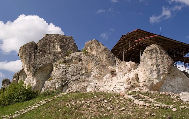
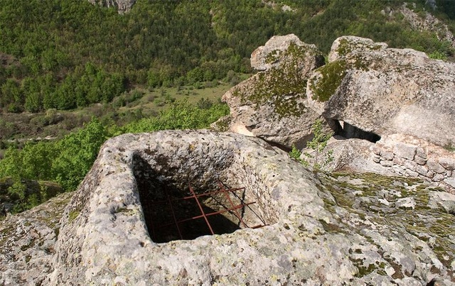
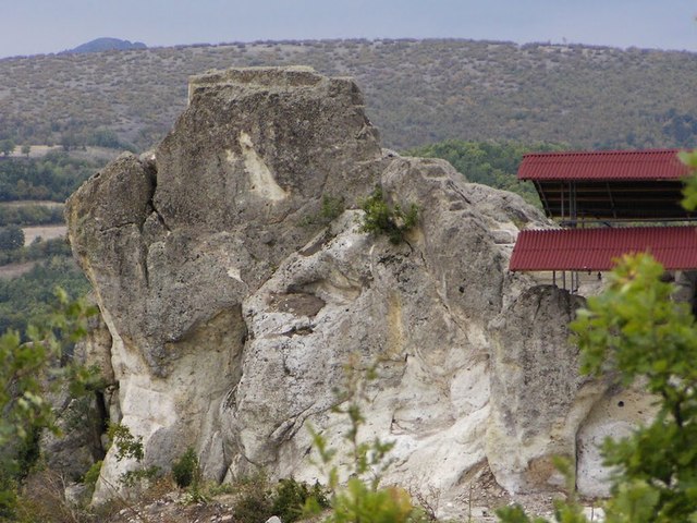
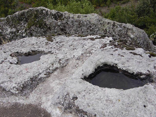
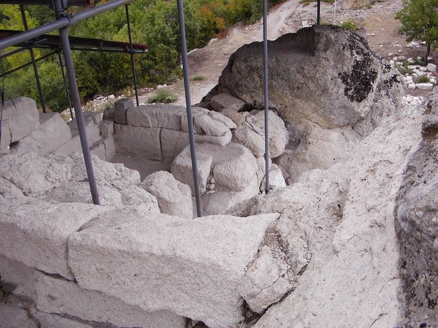
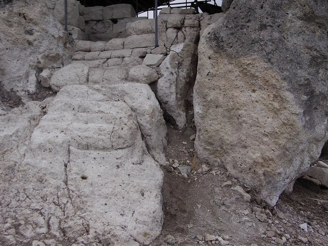
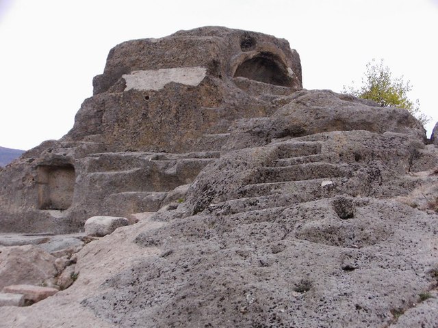
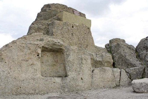
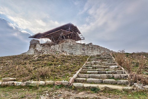
The complex consists of an ancient pagan temple and a medieval fortress. The central and highest place on the rock hill is occupied by a tomb with east-west orientation, carved in a solid "truncated pyramid"-like rock. On the south side of the majestic rock a similar tomb, located in hemispherical niche is carved. The niche is covered with arched, carved in the stone, vault. A ceremonial staircase, consisting of eight steps, leads to the two graves. Religious sites, steps to them, niche systems, chutes and pools to collect any liquid, are located on the neighboring rocks as well.
The sanctuary was started in the late Bronze Age. Archaeologists believe that 3,500 years ago the rock near Tatul was revered as heroon - sanctuary of the deified after his death Thracian king.
Besides a sanctuary of the ancient Thracian gods, this monument was also a center for monitoring the sunrise and the sunset on certain days of the year - the winter solstice, for example, when the rising sun is the center of the falls in a special rock crevice.
This form of the highest part of the megalith - an engraved crescent resembling a rising sun, supports that hypothesis. What is most peculiar here, is that this kind of sarcophagus is directed exactly towards the Sun at the equinox days. The "truncated pyramid" like rock where the sanctuary is located, does not have an equivalent in our lands.
Steps leading up to the top where a "sarcophagus" with 170 cm length is situated, were carved in the sanctuary. Experts suggest that the furrow around the sarcophagus was used for the flow of blood from the victim, placed in the sarcophagus. It is known that the Thracians worshiped the sun and the rituals they had were relevant to that cult. So the sacrifices were most probably made at sunrise (or sunset).
The hypothesis that this tomb was once the sanctuary of Orpheus himself was declared in the past century. However, this has not been certainly proved to this day.
It is a fact that a statuette of a naked god, man, upright and leaning with one hand on a lyre, with the other hand holding plektron - something like a pen used to play, was discovered in the sanctuary. The statuette dates back from the II - III century - the Roman era, and could be depicting Orpheus himself, but it might also be the Apollo /a Greek god/. Some of the findings of scientists are a ceramic rod of a priest, preserved clay icon lamp with beautiful ornaments, spindle-whorl, burden for a vertical loom in the form of a pyramid.
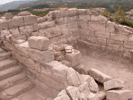
Orpheus' sanctuary was known throughout the world both before and after Christ. The newly come Romans worshiped the old gods and heroes and kept the welfare of the religious places. They repaired the ruined during the strife at the beginning of the new era places and built new buildings. That was how the complete temple complex, representing the best studied heroon in our land, arised. Upon the adoption of Christianity in the Rhodope Mountains at the end of IV century the rich complex was converted into a secular estate. It existed up to XI-XII century, when it became the property of the famous Byzantine Palaiologos family to become today one of the most remarkable architectural sites of our times.
TRANSPORT AND ACCOMODATION
The village of Tatul is easily reached via an asphalt road by car. "Orpheus 'sanctuary" can be reached if you start from the center of the village of Tatul. Тhere are signs pointing the road to the Thracian temple. There is also a small parking lot. One must go up the path among the houses of the village. The trail gradually turns into a narrow forest path. After about 10 minutes walking you reach the sanctuary.
The town of Momchilgrad offers excellent accommodation conditions. Several hotels, guest houses, restaurants and cafes are available for tourists.
Sources: http://setlans.wordpress.com, http://www.journey.bg, http://www.bulgariancastles.com
Photos: http://bulgariatravel.org, http://www.panoramio.com/

Chuprene Biosphere Reserve
The reserve is one of the largest biosphere reserves in Bulgaria. It is established in 1973 to preserve the northern coniferous forests of Bulgaria. In 1977 it was included in the list of biosphere reserves under the program "Man and Biosphere".
See on the map
Water Holes Cave
Water Holes Cave is located in Apriltsi Municipality, within the Central Balkan National Park on the northern slope of the massif of Botev Mount.
See on the map
Albotin rock monastery
Albotin monastery is an inactive Medieval rock monastery included in Vidin diocese.
See on the map
Uzana - the geographic center of Bulgaria
Uzana - the heart of the Balkans. In its embrace, the mountains has kept this extraordinary place where you can fully take charge with power and hours to enjoy its grandeur and beauty of nature.Far from the urban vanity you will find abundance of colors and shades, serenity and peace of mind. Here the warbling of the birds and the whisper of wild grasslands will put a spell on you forever.

Chervenitsa - geological phenomena over the village of Kunino
The natural phenomenon Chervenitsa is a molded boulder, rising more than 150 m above the terrace of the river Iskar in village of Kunino. It is located about 46 km east of Vratsa and approximately 120 km northeast of Sofia.
See on the map
The museum of salt
A unique museum in the whole Eastern Europe dedicated to the production of salt by solar evaporation of sea water, Pomorie
See on the map
Lopushanski monastery "Sv. Yoan Predtecha"
The Lopushanski monastery is located in the Balkan Mountain in the valley of Dalgodelska Ogosta river. It is operational and consists of a church, residential and farm buildings and a white stone fountain, all surrounded by a stone wall.
See on the map
Taukliman Reserve
Natural Reserve Taukliman typical landslide with length of about 4 km, formed between the edge of the Dobrudzhansko plateau and the coast.

Basilica Sveta Sofia - Sofia city
The Early Christian basilica Sveta Sofia is an active Orthodox church in the center of Sofia city. The church was probably built in the early VI century on the ruins of early Christian tombs from II - IV century and the ruins of two earlier churches from IV-V century. It is located among the necropolis of the ancient Serdica.
See on the map
Medieval fortress "Monyak"
"Monyak" fortress is one of the largest and high located fortresses in the Rhodopes near the village of Shiroko pole, Kardzhali Region
See on the map
Vakarelski monastery "St Petka"
Vakarelski monastery "St Petka" was found in XX century and now it is working occasionally. It was functioning as nunnery.
See on the map
"The Womb" cave
A unique Thracian temple near the village of Nenkovo, Kardzhali Region
See on the map
Thracian sanctuary "Gluhite kamani"
The megalithic complex "Gluhite kamani" is one of the largest Thracian sanctuaries since BC, whose strength continues to act today to anyone who visits it.
See on the map
Krivus Fortress
A medieval fortress located on a picturesque cliff above Arda River near the village of Bashevo, Kardzhali Region
See on the map
"St. Konstantin and Elena" monastery near Ladzha quarter, Ivaylovgrad
The monastery of Lazdha or Ivaylovrad monastery "St. Konstantin and Elena" is situated close to Ladzha quarter in the town of Ivaylovgrad
See on the map
Rakovitsa monastery Sveta Troitsa
Rakovitsa monastery Sveta Troitsa was was found in X-XI century and during the Middle Ages was an important literary and cultural center in Bdin area.
See on the map
Roman tomb - town of Hisarya
The Hisar tomb is a late Roman family tomb built in the second half of the IV-th century.
See on the map
Elenska basilica
Elenska basilica is early Christian temple that is preserved to nowadays and is situated in proximity to the town of Pirdop
See on the map
"St. Theodor Tyron and Theodor Stratilat" church
A unique monument of culture with extremely precious frescoes and icons included in UNESCO's list with the World Cultural Heritage, village of Dobarsko, Blagoevgrad Region
See on the map
Ovech Fortress
One of the oldest fortresses in Bulgaria located on a high mountain plateau above the town of Provadiya
See on the map