Fortress "Trayanovi vrata"
See on the map


Location: the fortress "Trayanovi vrata" is situated in Sredna gora mountain. It is 15 km from the town of Kostenets, 16 km from the town of Ihtiman and 70 km from the capital Sofia.
Trayanovi vrata is historical passage that now is tunnel on Trakiya highway. The passage is named after the Roman emperor Trayan. It was fortress back then. The fortress is also known as "Shtipon".
The fortress Trayanovi vrata was found during archeological excavations in 1985-1986 from professor Dimitrina Dzhonova. The region was inhabited during the Bronze and Iron age it was crossing point of many cultures and civilizations. This is the reason its vision at the moment to be a mixture of different elements constructed in various ages.
Its first inhabitants were the Thracian tribe Besi in the First century B.C. The Thracians called the passage Suki and is known since the V-th century B.C. when through it passed the war march of the Thracian king Sitalk. In the end of the first and the beginning if the II B.C. the territory was governed by the Roman province of Serdika. The passage connected Rome with the far eastern parts of the Empire as a part of the modern route Belgrade-Nish-Sofia-Trayanovi vrata-Plovdiv-Odrin-Istanbul.
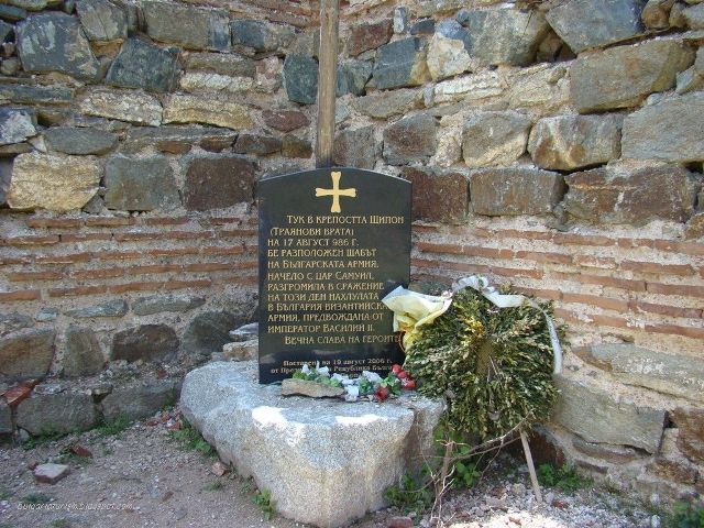
The exact time of the construction of the fortress is unknown and the first written records about it date back to the III century B.C. when it kept the Romans from the Barbarian attacks. During 831-836 the Bulgarian knyaz Malamir conquered the region and added it to the Bulgarian realm thus it became strategic commercial road for the country. The fortress itself occupies very important place in the history of Bulgaria. On 17-th august 986 from this fortress the future king Samuil led the Bulgarian army and destroyed in battle the Byzantium cavalry from 30000 soldiers led by the emperor Vasilii II.
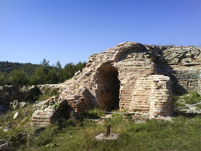
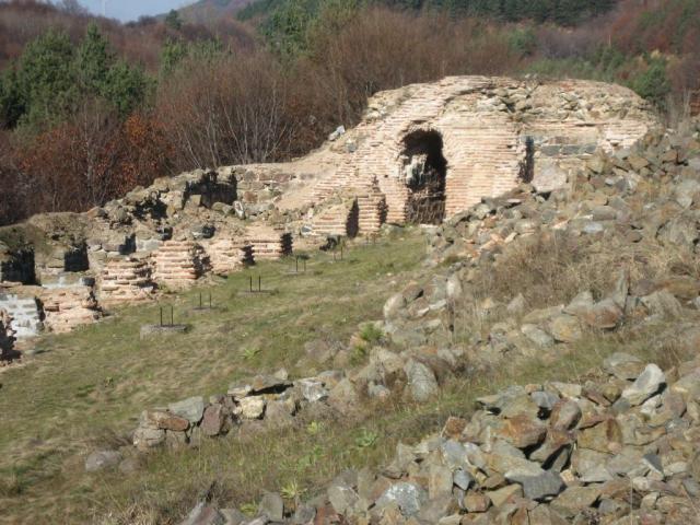
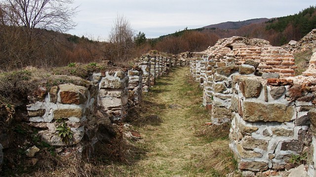
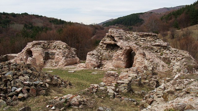
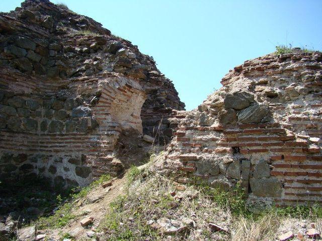
When it was found during excavations by professor Dzhonova the view of the fortress was impressive. The facility is naturally protected as it was constructed on a hill surrounded by river and forest. Only its northwest side is not protected but later there were constructed two high sharp towers. The building looks frightening for its huge size - 40 m width and 90 m length.
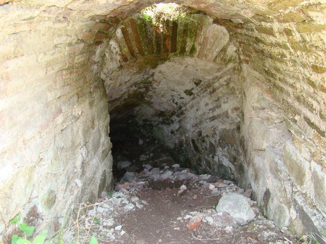
Trayanovi vrata fortress consists of garrison, three inner towers and two sharp towers, which are located on the west side, a unique water facility - 60 feet long tunnel that leads to an underground spring. The tunnel is located on the north wall, inside the fort is well preserved, but outside the city wall was completely destroyed. Great arch of the Roman gate, high about 18 meters, was preserved until the 19-th century. In the country there is no any such building. The shape of the towers is with sharp peaks and arched entrances make them unique for Bulgaria and even for the Balkans.
The fortress is archeological monument of culture with national significance. The area Trayanovi fortress is included in the National register of the protected areas and is characterized as historical spot. Today there can be seen the remains of the fortress and the 18 feet arch Roman gate.
Accommodation
About 10 km ride with car is from the town of Momin prohod where the tourist can use the hotel or guest house. 30 km from Trayanovi vrata are situated Borovets resort and the town of Velingrad where there also are hotels and SPA centers.
Transportation
To the fortress leads exit from Trakiya highway near the town of Kostenets and then 15 km ride in the mountain. A gravel road leads to the monument constructed in honor of the 1000 years from the victory of the Samuil's army over the Byzantium and just one kilometers away is Trayanovi vrata fortress.
Sources: bg.wikipedia.org, bulgariaturism.blogspot.com, kostenets-tourism.com, razhodka.bg
Photos: Internet

Chuprene Biosphere Reserve
The reserve is one of the largest biosphere reserves in Bulgaria. It is established in 1973 to preserve the northern coniferous forests of Bulgaria. In 1977 it was included in the list of biosphere reserves under the program "Man and Biosphere".
See on the map
Water Holes Cave
Water Holes Cave is located in Apriltsi Municipality, within the Central Balkan National Park on the northern slope of the massif of Botev Mount.
See on the map
Albotin rock monastery
Albotin monastery is an inactive Medieval rock monastery included in Vidin diocese.
See on the map
Uzana - the geographic center of Bulgaria
Uzana - the heart of the Balkans. In its embrace, the mountains has kept this extraordinary place where you can fully take charge with power and hours to enjoy its grandeur and beauty of nature.Far from the urban vanity you will find abundance of colors and shades, serenity and peace of mind. Here the warbling of the birds and the whisper of wild grasslands will put a spell on you forever.

Chervenitsa - geological phenomena over the village of Kunino
The natural phenomenon Chervenitsa is a molded boulder, rising more than 150 m above the terrace of the river Iskar in village of Kunino. It is located about 46 km east of Vratsa and approximately 120 km northeast of Sofia.
See on the map
The museum of salt
A unique museum in the whole Eastern Europe dedicated to the production of salt by solar evaporation of sea water, Pomorie
See on the map
Lopushanski monastery "Sv. Yoan Predtecha"
The Lopushanski monastery is located in the Balkan Mountain in the valley of Dalgodelska Ogosta river. It is operational and consists of a church, residential and farm buildings and a white stone fountain, all surrounded by a stone wall.
See on the map
Taukliman Reserve
Natural Reserve Taukliman typical landslide with length of about 4 km, formed between the edge of the Dobrudzhansko plateau and the coast.

Basilica Sveta Sofia - Sofia city
The Early Christian basilica Sveta Sofia is an active Orthodox church in the center of Sofia city. The church was probably built in the early VI century on the ruins of early Christian tombs from II - IV century and the ruins of two earlier churches from IV-V century. It is located among the necropolis of the ancient Serdica.
See on the map
Medieval fortress "Monyak"
"Monyak" fortress is one of the largest and high located fortresses in the Rhodopes near the village of Shiroko pole, Kardzhali Region
See on the map
Vakarelski monastery "St Petka"
Vakarelski monastery "St Petka" was found in XX century and now it is working occasionally. It was functioning as nunnery.
See on the map
"The Womb" cave
A unique Thracian temple near the village of Nenkovo, Kardzhali Region
See on the map
Thracian sanctuary "Gluhite kamani"
The megalithic complex "Gluhite kamani" is one of the largest Thracian sanctuaries since BC, whose strength continues to act today to anyone who visits it.
See on the map
Krivus Fortress
A medieval fortress located on a picturesque cliff above Arda River near the village of Bashevo, Kardzhali Region
See on the map
"St. Konstantin and Elena" monastery near Ladzha quarter, Ivaylovgrad
The monastery of Lazdha or Ivaylovrad monastery "St. Konstantin and Elena" is situated close to Ladzha quarter in the town of Ivaylovgrad
See on the map
Rakovitsa monastery Sveta Troitsa
Rakovitsa monastery Sveta Troitsa was was found in X-XI century and during the Middle Ages was an important literary and cultural center in Bdin area.
See on the map
Roman tomb - town of Hisarya
The Hisar tomb is a late Roman family tomb built in the second half of the IV-th century.
See on the map
Elenska basilica
Elenska basilica is early Christian temple that is preserved to nowadays and is situated in proximity to the town of Pirdop
See on the map
"St. Theodor Tyron and Theodor Stratilat" church
A unique monument of culture with extremely precious frescoes and icons included in UNESCO's list with the World Cultural Heritage, village of Dobarsko, Blagoevgrad Region
See on the map
Ovech Fortress
One of the oldest fortresses in Bulgaria located on a high mountain plateau above the town of Provadiya
See on the map