The Stone wedding
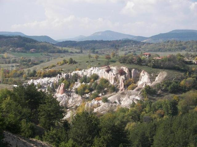
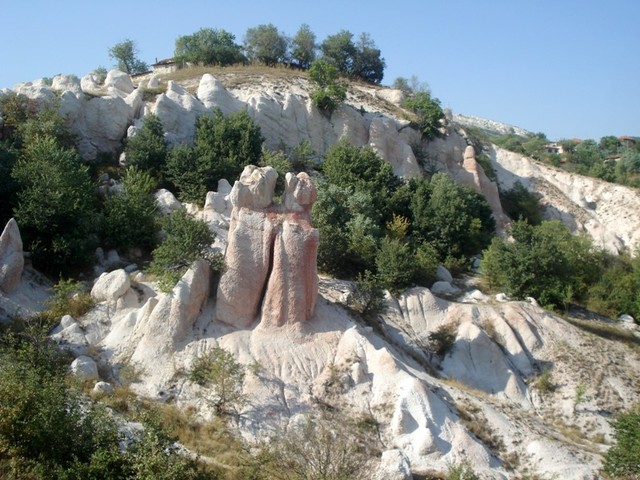
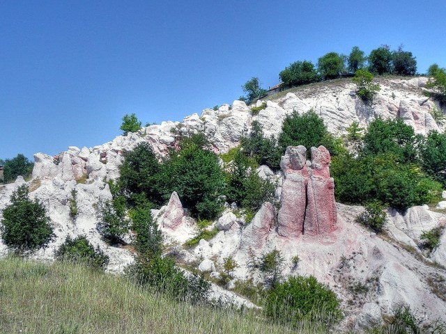
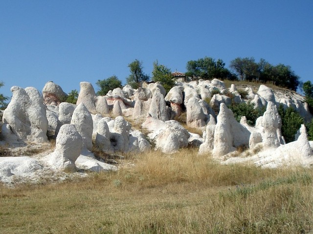
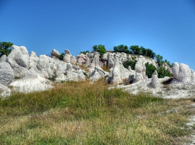
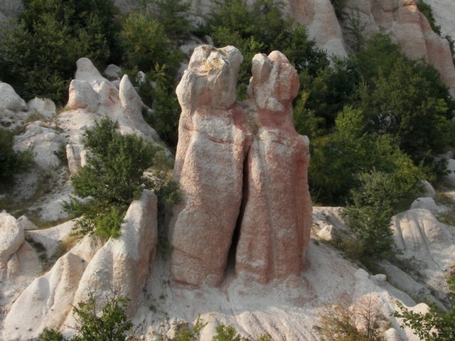
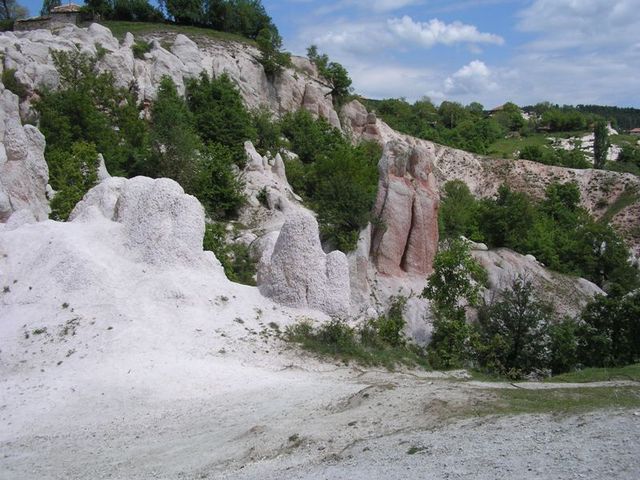
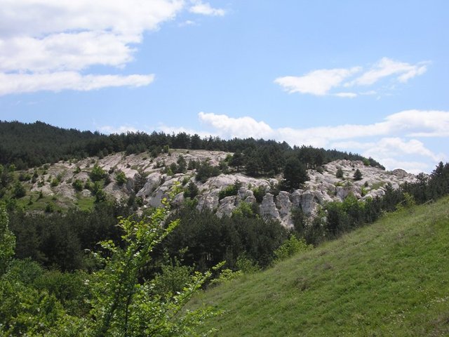
The Stone wedding is a rock phenomenon, located in village of Zimzelen, 3 km north-east of town of Kardzhali.
It occupies area of 5.0 ha in the settlement of Zimzelen. This is a complex of mild rock formations of volcano origin with interesting shapes made by nature. They are in white and pink colours, about 0.5 m - 10 m high.
Origin
The Stone wedding formation had started nearly 40-50 million years ago, when the Eastern Rhodopes had been the bottom of a warm, shallow sea that had been shaken by continuous volcano activity. The sediment ash and the rock pieces had formed beautiful rocks - rhyolitic tuffs. After the sea level had changed as a result of the vertical movements of the ground crust, the rhyolitic tuffs had risen and had been exposed to weather geological processes. The main factors of formation and constantly renewing of the rocks are rain, running water, summer heats and winter cold. The natural elements had sculptured in the volcano crumbling tuffs interesting figures with various shapes and sizes. The rocks contain different minerals which give them different colours - white, yellow, pink, green, red.
The legend
Human imagination sees in this composition a wedding procession, connected with impressive legend. According to the legend a local young man fell in love with a pretty girl from the neighbouring village. The girls of that time used to cover their faces with veils and only their eyes could be seen. The old father of the young man went to the parents of the girl to ask for her hand. They gave a big wedding party and festively set off for Zimzelen. Suddenly high wind started and blew away the veil of the bride. All were struck by her beauty and the father-in-law envied his son. Because of his impure intentions immediately all wedding-guests turned into stone. Only the bridegroom survived. He started crying with bitter tears and asked the wind to turn him into stone as well. The wind fulfilled his wish. The stone wedding procession still stands next to a puddle - the wet tears of the miserable bridegroom.
The site was declared Natural landmark in the year of 1974. It is suitable for tourism. There is a marked path to it. The place is easily accessible by car. There is about 100 m climbing on a steep path.
Internet sources: http://bgmountains.org, www.kardzhali-tourism.info
Pictures: www.kardzhali-tourism.info, www.panoramio.com

Chuprene Biosphere Reserve
The reserve is one of the largest biosphere reserves in Bulgaria. It is established in 1973 to preserve the northern coniferous forests of Bulgaria. In 1977 it was included in the list of biosphere reserves under the program "Man and Biosphere".
See on the map
Water Holes Cave
Water Holes Cave is located in Apriltsi Municipality, within the Central Balkan National Park on the northern slope of the massif of Botev Mount.
See on the map
Albotin rock monastery
Albotin monastery is an inactive Medieval rock monastery included in Vidin diocese.
See on the map
Uzana - the geographic center of Bulgaria
Uzana - the heart of the Balkans. In its embrace, the mountains has kept this extraordinary place where you can fully take charge with power and hours to enjoy its grandeur and beauty of nature.Far from the urban vanity you will find abundance of colors and shades, serenity and peace of mind. Here the warbling of the birds and the whisper of wild grasslands will put a spell on you forever.

Chervenitsa - geological phenomena over the village of Kunino
The natural phenomenon Chervenitsa is a molded boulder, rising more than 150 m above the terrace of the river Iskar in village of Kunino. It is located about 46 km east of Vratsa and approximately 120 km northeast of Sofia.
See on the map
The museum of salt
A unique museum in the whole Eastern Europe dedicated to the production of salt by solar evaporation of sea water, Pomorie
See on the map
Lopushanski monastery "Sv. Yoan Predtecha"
The Lopushanski monastery is located in the Balkan Mountain in the valley of Dalgodelska Ogosta river. It is operational and consists of a church, residential and farm buildings and a white stone fountain, all surrounded by a stone wall.
See on the map
Taukliman Reserve
Natural Reserve Taukliman typical landslide with length of about 4 km, formed between the edge of the Dobrudzhansko plateau and the coast.

Basilica Sveta Sofia - Sofia city
The Early Christian basilica Sveta Sofia is an active Orthodox church in the center of Sofia city. The church was probably built in the early VI century on the ruins of early Christian tombs from II - IV century and the ruins of two earlier churches from IV-V century. It is located among the necropolis of the ancient Serdica.
See on the map
Medieval fortress "Monyak"
"Monyak" fortress is one of the largest and high located fortresses in the Rhodopes near the village of Shiroko pole, Kardzhali Region
See on the map
Vakarelski monastery "St Petka"
Vakarelski monastery "St Petka" was found in XX century and now it is working occasionally. It was functioning as nunnery.
See on the map
"The Womb" cave
A unique Thracian temple near the village of Nenkovo, Kardzhali Region
See on the map
Thracian sanctuary "Gluhite kamani"
The megalithic complex "Gluhite kamani" is one of the largest Thracian sanctuaries since BC, whose strength continues to act today to anyone who visits it.
See on the map
Krivus Fortress
A medieval fortress located on a picturesque cliff above Arda River near the village of Bashevo, Kardzhali Region
See on the map
"St. Konstantin and Elena" monastery near Ladzha quarter, Ivaylovgrad
The monastery of Lazdha or Ivaylovrad monastery "St. Konstantin and Elena" is situated close to Ladzha quarter in the town of Ivaylovgrad
See on the map
Rakovitsa monastery Sveta Troitsa
Rakovitsa monastery Sveta Troitsa was was found in X-XI century and during the Middle Ages was an important literary and cultural center in Bdin area.
See on the map
Roman tomb - town of Hisarya
The Hisar tomb is a late Roman family tomb built in the second half of the IV-th century.
See on the map
Elenska basilica
Elenska basilica is early Christian temple that is preserved to nowadays and is situated in proximity to the town of Pirdop
See on the map
"St. Theodor Tyron and Theodor Stratilat" church
A unique monument of culture with extremely precious frescoes and icons included in UNESCO's list with the World Cultural Heritage, village of Dobarsko, Blagoevgrad Region
See on the map
Ovech Fortress
One of the oldest fortresses in Bulgaria located on a high mountain plateau above the town of Provadiya
See on the map