The Seven Lakes of Rila mountain

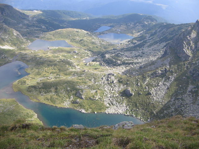
The cirque of the Seven Rila Lakes is the largest in all of Rila Mountain. It is centered East of Haidyta Peak (also known as Hermit Peak) and South of the steap rock slopes of Razdela Ridge and Otovishka Peak, found to the West of the peak directly above Kidney lake. The cirque opens to the North and feeds the German River, which is a main source of the Stryma River.
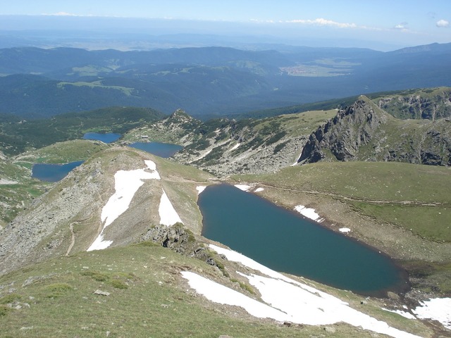
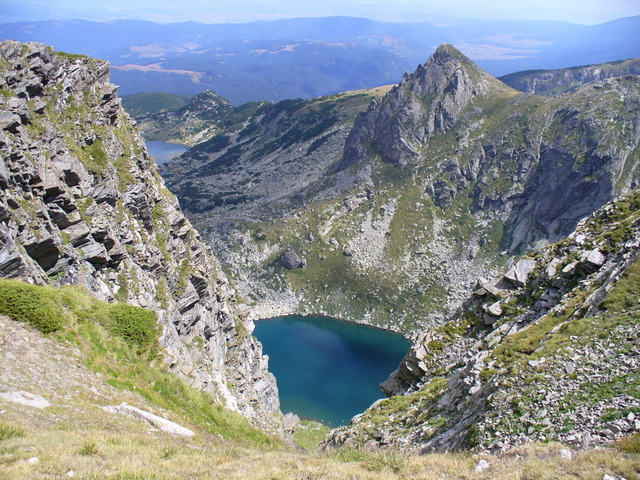
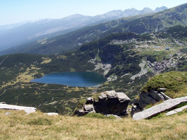
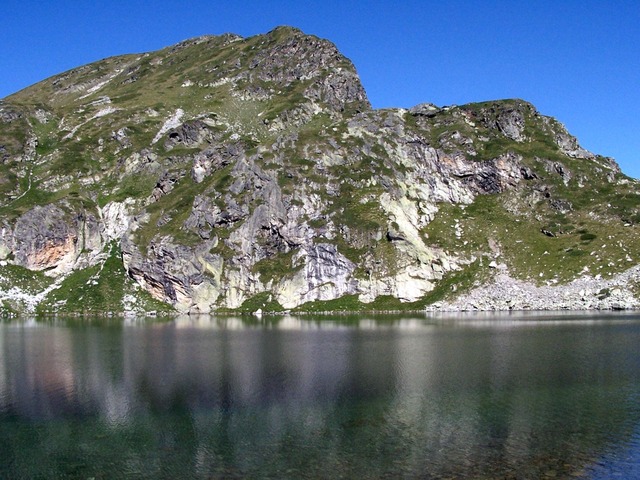
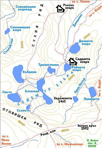
The lakes of the cirque are found at differing altitudes and appear like large footprints or steps leading up the mountain. They are the most picturesque and visited group of lakes in Rila Mountain. They are all named according to their shapes and officially numbered from the top to the bottom. The entire area is maintained within the boundaries of Rila National Park.
The Seven Rila Lakes is an extremely sensitive and wonderous spot on Rila Mountain. Many of its species are endemic and listed in the Red Data Book of Flora and Fauna, which denotes them as endangered or rare.
The first lake - Salzata /'"The Tear'"/ is the highest of the Rila Lakes. It is found at 2535 meters above sea level and has an area of 0.7 hectares. It is 4.5 meters at its deepest.
The 2nd - Okoto /'"The Eye'"/ is found at 2440 meters above sea level and has an area of 6.8 hectares. It is the deepest of thelakes with a depth of 37.5 meters.
The 3rd - Babreka /'"The Kidney'"/ is at an altitude of 2282 meters above sea level and has an area of 8.5 hectares. It is 28 meters at its deepest.
The 4th - Bliznaka /'"The Twin'"/ are actually one lake nearly split into two. They are at 2243 meters above sea level and is the largest and longest of the lakes. It has an area of 9.1 hectares and a depth of 27.5 meters.
The 5th - Trilistnika /'"Three-Lobed Lake'"/ has an irregular shape and steep banks and is found at 2216 meters above sea level. It is 6.5 meters deep and has a total area of 2.6 hectares.
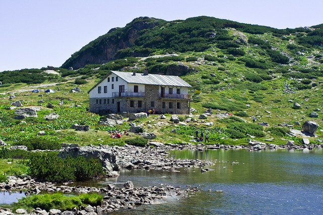
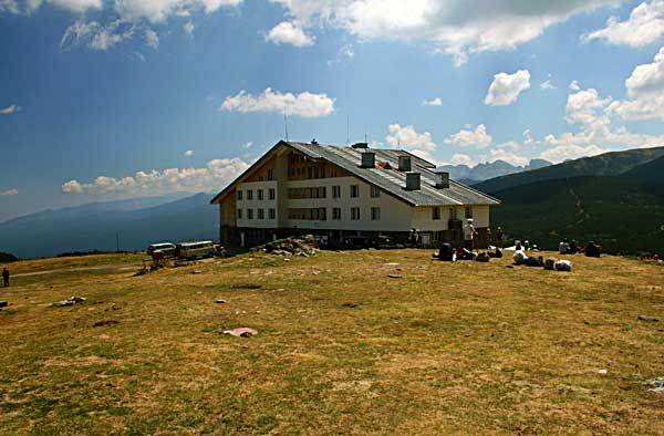
The 6th - Ribnoto ezero /'"The Fish Lake'"/ is found at 2184 meters above seal level and has an area of 3.5 hectares. It is the shallowest of the lakes at 2.5 meters. The 7 Lakes Lodge is found at its most Northern bank.
The 7th - Dolnoto ezero /'"The Low Lake'"/ is at 2095 meteres above sea level, has an area of 5.9 hectares and is 11 meters deep.
This is actually one of the most famous and attractive tourist places, which for decades is one of the most visited mountain areas in Bulgaria. The terrain is suitable for visitors of all ages who love to enjoy the mountain splendor, beauty and purity.

Chuprene Biosphere Reserve
The reserve is one of the largest biosphere reserves in Bulgaria. It is established in 1973 to preserve the northern coniferous forests of Bulgaria. In 1977 it was included in the list of biosphere reserves under the program "Man and Biosphere".
See on the map
Water Holes Cave
Water Holes Cave is located in Apriltsi Municipality, within the Central Balkan National Park on the northern slope of the massif of Botev Mount.
See on the map
Albotin rock monastery
Albotin monastery is an inactive Medieval rock monastery included in Vidin diocese.
See on the map
Uzana - the geographic center of Bulgaria
Uzana - the heart of the Balkans. In its embrace, the mountains has kept this extraordinary place where you can fully take charge with power and hours to enjoy its grandeur and beauty of nature.Far from the urban vanity you will find abundance of colors and shades, serenity and peace of mind. Here the warbling of the birds and the whisper of wild grasslands will put a spell on you forever.

Chervenitsa - geological phenomena over the village of Kunino
The natural phenomenon Chervenitsa is a molded boulder, rising more than 150 m above the terrace of the river Iskar in village of Kunino. It is located about 46 km east of Vratsa and approximately 120 km northeast of Sofia.
See on the map
Lopushanski monastery "Sv. Yoan Predtecha"
The Lopushanski monastery is located in the Balkan Mountain in the valley of Dalgodelska Ogosta river. It is operational and consists of a church, residential and farm buildings and a white stone fountain, all surrounded by a stone wall.
See on the map
The museum of salt
A unique museum in the whole Eastern Europe dedicated to the production of salt by solar evaporation of sea water, Pomorie
See on the map
Taukliman Reserve
Natural Reserve Taukliman typical landslide with length of about 4 km, formed between the edge of the Dobrudzhansko plateau and the coast.

Basilica Sveta Sofia - Sofia city
The Early Christian basilica Sveta Sofia is an active Orthodox church in the center of Sofia city. The church was probably built in the early VI century on the ruins of early Christian tombs from II - IV century and the ruins of two earlier churches from IV-V century. It is located among the necropolis of the ancient Serdica.
See on the map
Medieval fortress "Monyak"
"Monyak" fortress is one of the largest and high located fortresses in the Rhodopes near the village of Shiroko pole, Kardzhali Region
See on the map
Vakarelski monastery "St Petka"
Vakarelski monastery "St Petka" was found in XX century and now it is working occasionally. It was functioning as nunnery.
See on the map
"The Womb" cave
A unique Thracian temple near the village of Nenkovo, Kardzhali Region
See on the map
Thracian sanctuary "Gluhite kamani"
The megalithic complex "Gluhite kamani" is one of the largest Thracian sanctuaries since BC, whose strength continues to act today to anyone who visits it.
See on the map
Krivus Fortress
A medieval fortress located on a picturesque cliff above Arda River near the village of Bashevo, Kardzhali Region
See on the map
"St. Konstantin and Elena" monastery near Ladzha quarter, Ivaylovgrad
The monastery of Lazdha or Ivaylovrad monastery "St. Konstantin and Elena" is situated close to Ladzha quarter in the town of Ivaylovgrad
See on the map
Rakovitsa monastery Sveta Troitsa
Rakovitsa monastery Sveta Troitsa was was found in X-XI century and during the Middle Ages was an important literary and cultural center in Bdin area.
See on the map
Roman tomb - town of Hisarya
The Hisar tomb is a late Roman family tomb built in the second half of the IV-th century.
See on the map
Elenska basilica
Elenska basilica is early Christian temple that is preserved to nowadays and is situated in proximity to the town of Pirdop
See on the map
"St. Theodor Tyron and Theodor Stratilat" church
A unique monument of culture with extremely precious frescoes and icons included in UNESCO's list with the World Cultural Heritage, village of Dobarsko, Blagoevgrad Region
See on the map
Ovech Fortress
One of the oldest fortresses in Bulgaria located on a high mountain plateau above the town of Provadiya
See on the map