Medievаl town of Cherven
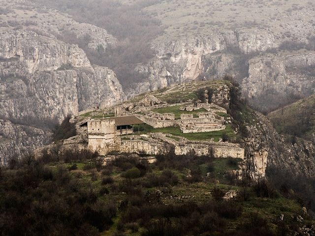
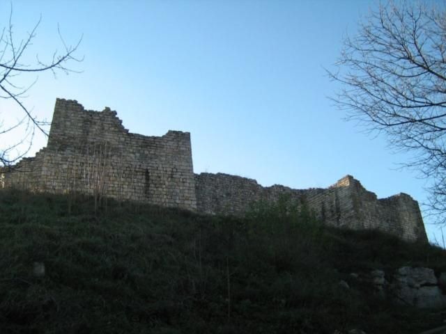
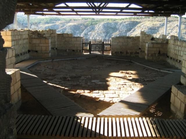
Cherven was one of the biggest towns of Bulgaria in the period of 12th-14th century. Its inhabitants were Thracians (4th - 2nd century B.C.) and Byzantines (4th - 6th century A.D.). It had been a bishop's residence and a craft centre. The mediaeval town is situated on a high hill in the canyon of the river Cherni Lom, 35 km south of Ruse. There are different historical and archaeological sites in its surroundings - prehistoric, ancient and medieval fortresses, settlements and necropolises. The most impressive are the numerous Christian rock monasteries. Mediaeval frescos are preserved in some of them.
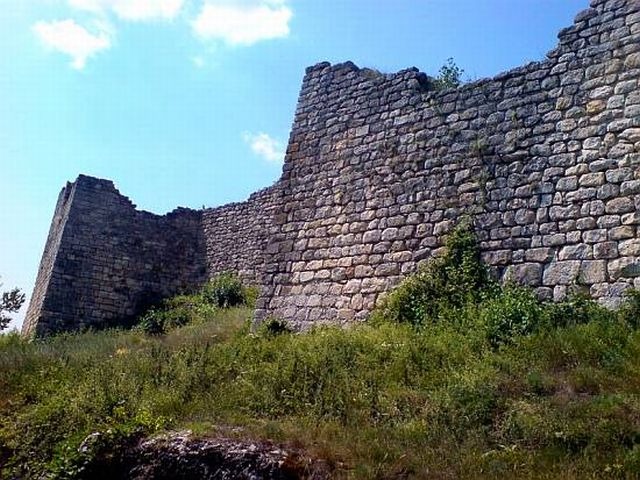
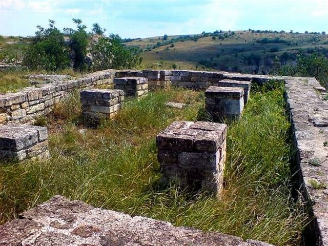
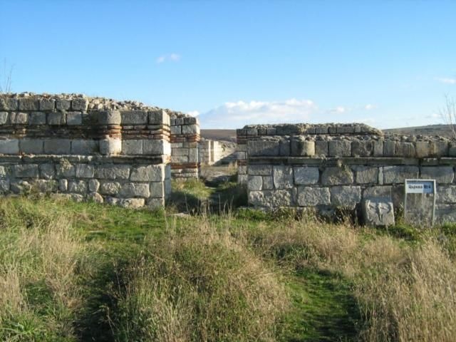
The stronghold of Cherven (Bulgarian: Червен, 'red') was one of the Second Bulgarian Empire's primary military, administrative, economic and cultural centres between the 12th and the 14th century. The riuns of the fortress are located near the village of the same name 30-35 km south of Ruse, northeastern Bulgaria.
The town was a successor to an earlier Byzantine fortress of the 6th century, but the area has been inhabited since the arrival of the Thracians. Cherven was first mentioned in the 11th century in an Old Bulgarian apocryphal chronicle. It gained importance after 1235, when it became the seat of the medieval Bulgarian Orthodox Bishopric of Cherven. It was affected by the Mongol Golden Horde raids in 1242 and was briefly conquered by Byzantine troops during the reign of Tsar Ivailo (1278-1280).
During the second half of the 14th century, the stronghold's area exceded 1 km² and had intensive urban development, including a fortified inner city on vast rock ground in one of the Cherni Lom river's bends, and an outer city at the foot of the rocks and on the neighbouring hills. The town had complex fortification system and was completely built up. Cherven grew to become a centre of craftsmanship in the 14th century, with iron extraction, ironworking, goldsmithing, construction and arts being well developed. The town was an important junction of roads from the Danube to the country's interior, which also made the town a key centre of trade.
Cherven was conquered by the Ottoman Turks in 1388, initially retaining its administrative functions but later declining in importance. The modern village of Cherven located close to the ruins of the fortress has, as of September 2005, 302 inhabitants.

Chuprene Biosphere Reserve
The reserve is one of the largest biosphere reserves in Bulgaria. It is established in 1973 to preserve the northern coniferous forests of Bulgaria. In 1977 it was included in the list of biosphere reserves under the program "Man and Biosphere".
See on the map
Water Holes Cave
Water Holes Cave is located in Apriltsi Municipality, within the Central Balkan National Park on the northern slope of the massif of Botev Mount.
See on the map
Albotin rock monastery
Albotin monastery is an inactive Medieval rock monastery included in Vidin diocese.
See on the map
Uzana - the geographic center of Bulgaria
Uzana - the heart of the Balkans. In its embrace, the mountains has kept this extraordinary place where you can fully take charge with power and hours to enjoy its grandeur and beauty of nature.Far from the urban vanity you will find abundance of colors and shades, serenity and peace of mind. Here the warbling of the birds and the whisper of wild grasslands will put a spell on you forever.

Chervenitsa - geological phenomena over the village of Kunino
The natural phenomenon Chervenitsa is a molded boulder, rising more than 150 m above the terrace of the river Iskar in village of Kunino. It is located about 46 km east of Vratsa and approximately 120 km northeast of Sofia.
See on the map
Lopushanski monastery "Sv. Yoan Predtecha"
The Lopushanski monastery is located in the Balkan Mountain in the valley of Dalgodelska Ogosta river. It is operational and consists of a church, residential and farm buildings and a white stone fountain, all surrounded by a stone wall.
See on the map
The museum of salt
A unique museum in the whole Eastern Europe dedicated to the production of salt by solar evaporation of sea water, Pomorie
See on the map
Taukliman Reserve
Natural Reserve Taukliman typical landslide with length of about 4 km, formed between the edge of the Dobrudzhansko plateau and the coast.

Basilica Sveta Sofia - Sofia city
The Early Christian basilica Sveta Sofia is an active Orthodox church in the center of Sofia city. The church was probably built in the early VI century on the ruins of early Christian tombs from II - IV century and the ruins of two earlier churches from IV-V century. It is located among the necropolis of the ancient Serdica.
See on the map
Medieval fortress "Monyak"
"Monyak" fortress is one of the largest and high located fortresses in the Rhodopes near the village of Shiroko pole, Kardzhali Region
See on the map
Vakarelski monastery "St Petka"
Vakarelski monastery "St Petka" was found in XX century and now it is working occasionally. It was functioning as nunnery.
See on the map
"The Womb" cave
A unique Thracian temple near the village of Nenkovo, Kardzhali Region
See on the map
Thracian sanctuary "Gluhite kamani"
The megalithic complex "Gluhite kamani" is one of the largest Thracian sanctuaries since BC, whose strength continues to act today to anyone who visits it.
See on the map
Krivus Fortress
A medieval fortress located on a picturesque cliff above Arda River near the village of Bashevo, Kardzhali Region
See on the map
"St. Konstantin and Elena" monastery near Ladzha quarter, Ivaylovgrad
The monastery of Lazdha or Ivaylovrad monastery "St. Konstantin and Elena" is situated close to Ladzha quarter in the town of Ivaylovgrad
See on the map
Rakovitsa monastery Sveta Troitsa
Rakovitsa monastery Sveta Troitsa was was found in X-XI century and during the Middle Ages was an important literary and cultural center in Bdin area.
See on the map
Roman tomb - town of Hisarya
The Hisar tomb is a late Roman family tomb built in the second half of the IV-th century.
See on the map
Elenska basilica
Elenska basilica is early Christian temple that is preserved to nowadays and is situated in proximity to the town of Pirdop
See on the map
"St. Theodor Tyron and Theodor Stratilat" church
A unique monument of culture with extremely precious frescoes and icons included in UNESCO's list with the World Cultural Heritage, village of Dobarsko, Blagoevgrad Region
See on the map
Ovech Fortress
One of the oldest fortresses in Bulgaria located on a high mountain plateau above the town of Provadiya
See on the map