Samuil Fortress
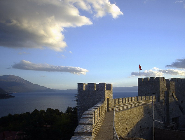
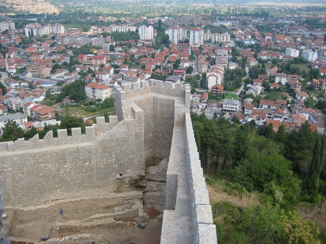
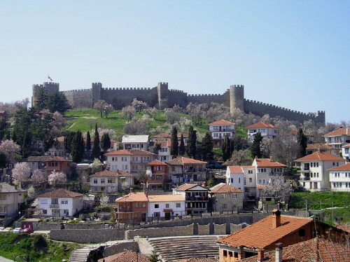
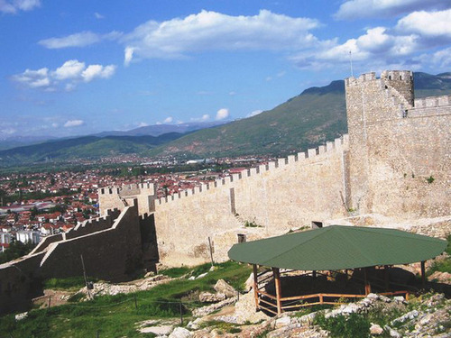
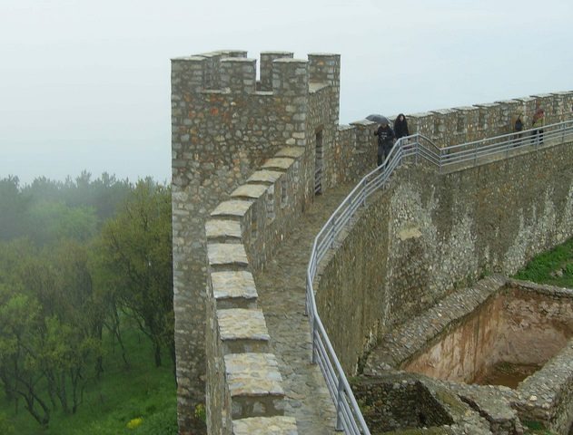
Samuil Fortress is located on the right bank of Strumeshnitsa River between the foothills of Belasitsa and Ograzhden Mountains in the so-called Klyuchka gorge. It is 5 km north of village of Klyuch, in the region of town of Petrich.
It was built probably in the period of 1009-1013 during the reign of Tsar Samuil. It is part of a massive fortification system.
It was constructed on the foundations of a Thracian and early Slav settlement. Tsar Samuil built on the hill an earth fort, protected by three shafts and two moats, which were concentrically situated.
The location of Samuil Fortress lets the control of the entire gorge. It could be used as military and strategic command post of all sectors of the defence system.
The fortification bears the scars of the Bulgarian fortification tradition characteristic of the First Bulgarian Kingdom. The castle is associated with the blindness of the Bulgarian warriors during the reign of Tsar Samuil. In the vicinity of the fortress in the summer of 1014 took place Belasishka historical battle in which Bulgarian troops were led by Tsar Samuil. The troops of Byzantine Emperor Basil II defeated the Bulgarian army and captured many soldiers. Tsar Samuil and his entourage escaped. After the battle the Byzantine emperor blinded the captured 14 000 Bulgarian army, as in every hundred he left one one-eyed leader.
National park-museum 'Samuil Fortress' was officially opened on October 23, 1982. The remains of the fortress and the village are preserved and the surrounding area is urbanized. Along the riverbank a beautiful alley leads to the park museum from the parking lot to the international road Petrich-checkpoint Zlatarevo. It passes under a pedestrian bridge and heads to the hill. Remotely seen are the magnificent bronze statue of Tsar Samuil full-length and the four concrete pylons built on the top of the hill, on the ruins of a medieval tower. Author of the monument is Professor Boris Gondov.
The fortress is an important tourist site in South-western Bulgaria. Since 2003 it has been included in the list of the 100 national tourist sites of the Bulgarian Tourist Union.
Internet source and pictures: http://bg.wikipedia.org

Chuprene Biosphere Reserve
The reserve is one of the largest biosphere reserves in Bulgaria. It is established in 1973 to preserve the northern coniferous forests of Bulgaria. In 1977 it was included in the list of biosphere reserves under the program "Man and Biosphere".
See on the map
Water Holes Cave
Water Holes Cave is located in Apriltsi Municipality, within the Central Balkan National Park on the northern slope of the massif of Botev Mount.
See on the map
Albotin rock monastery
Albotin monastery is an inactive Medieval rock monastery included in Vidin diocese.
See on the map
Uzana - the geographic center of Bulgaria
Uzana - the heart of the Balkans. In its embrace, the mountains has kept this extraordinary place where you can fully take charge with power and hours to enjoy its grandeur and beauty of nature.Far from the urban vanity you will find abundance of colors and shades, serenity and peace of mind. Here the warbling of the birds and the whisper of wild grasslands will put a spell on you forever.

Chervenitsa - geological phenomena over the village of Kunino
The natural phenomenon Chervenitsa is a molded boulder, rising more than 150 m above the terrace of the river Iskar in village of Kunino. It is located about 46 km east of Vratsa and approximately 120 km northeast of Sofia.
See on the map
The museum of salt
A unique museum in the whole Eastern Europe dedicated to the production of salt by solar evaporation of sea water, Pomorie
See on the map
Lopushanski monastery "Sv. Yoan Predtecha"
The Lopushanski monastery is located in the Balkan Mountain in the valley of Dalgodelska Ogosta river. It is operational and consists of a church, residential and farm buildings and a white stone fountain, all surrounded by a stone wall.
See on the map
Taukliman Reserve
Natural Reserve Taukliman typical landslide with length of about 4 km, formed between the edge of the Dobrudzhansko plateau and the coast.

Basilica Sveta Sofia - Sofia city
The Early Christian basilica Sveta Sofia is an active Orthodox church in the center of Sofia city. The church was probably built in the early VI century on the ruins of early Christian tombs from II - IV century and the ruins of two earlier churches from IV-V century. It is located among the necropolis of the ancient Serdica.
See on the map
Medieval fortress "Monyak"
"Monyak" fortress is one of the largest and high located fortresses in the Rhodopes near the village of Shiroko pole, Kardzhali Region
See on the map
Vakarelski monastery "St Petka"
Vakarelski monastery "St Petka" was found in XX century and now it is working occasionally. It was functioning as nunnery.
See on the map
"The Womb" cave
A unique Thracian temple near the village of Nenkovo, Kardzhali Region
See on the map
Thracian sanctuary "Gluhite kamani"
The megalithic complex "Gluhite kamani" is one of the largest Thracian sanctuaries since BC, whose strength continues to act today to anyone who visits it.
See on the map
Krivus Fortress
A medieval fortress located on a picturesque cliff above Arda River near the village of Bashevo, Kardzhali Region
See on the map
"St. Konstantin and Elena" monastery near Ladzha quarter, Ivaylovgrad
The monastery of Lazdha or Ivaylovrad monastery "St. Konstantin and Elena" is situated close to Ladzha quarter in the town of Ivaylovgrad
See on the map
Rakovitsa monastery Sveta Troitsa
Rakovitsa monastery Sveta Troitsa was was found in X-XI century and during the Middle Ages was an important literary and cultural center in Bdin area.
See on the map
Roman tomb - town of Hisarya
The Hisar tomb is a late Roman family tomb built in the second half of the IV-th century.
See on the map
Elenska basilica
Elenska basilica is early Christian temple that is preserved to nowadays and is situated in proximity to the town of Pirdop
See on the map
"St. Theodor Tyron and Theodor Stratilat" church
A unique monument of culture with extremely precious frescoes and icons included in UNESCO's list with the World Cultural Heritage, village of Dobarsko, Blagoevgrad Region
See on the map
Ovech Fortress
One of the oldest fortresses in Bulgaria located on a high mountain plateau above the town of Provadiya
See on the map