Vakarelski monastery "St Petka"
See on the map
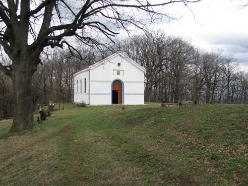
Vakarelski monastery "St Petka" is working occasionally holy place in West Bulgaria. It falls within Ihtiman municipality, Sofia region.
It is situated about 2 km south of the village of Vakarel, 20 km southeast of the town of Ihtiman and 37 km northwest of the town of Kostenets. The capital Sofia is 38 km northwest.
It is located at the foot of Vakarel mountain and it is part of the Ihtiman Sredna gora. The area around Vakarel is very picturesque and there are many places suitable for tourism and excursions in the nature. Also the villa zone that is at the foot of Sredna gora is ideal for relaxation.
History and architecture
There is little information about the history of the monastery. According to one of the legends the monastery was found in XVIII with the permission of the Ottoman rule. Local Turk and his family later stood for its reconstruction and kept it safe from the bashibozuks after the April rebellion (1876). The holy place was working and flourished until 1944 when the monks were banished by the Communists and the buildings were turned into cattle-sheds. During those hard years the church was opened only on its holiday - Petkovden (14 October).
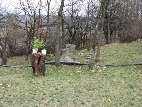
Today the monastery is complex of one nave and one apse church and small residential building. It is constructed in the XX century and worked as women monastery. At the moment one nun takes care for it.
Transportation
To the village of Vakarel there is railway transportation and also to it leads road E80 that is near Trakiya highway. When getting to the village there are left just 2 km gravel road.
Accommodation
In Vakarel monastery is not offered food or accommodation but just three kilometers away is working guest house with all amenities.
Sources: http://www.bulgariamonasteries.com http://svetimesta.com
Photos: http://www.panoramio.com

Chuprene Biosphere Reserve
The reserve is one of the largest biosphere reserves in Bulgaria. It is established in 1973 to preserve the northern coniferous forests of Bulgaria. In 1977 it was included in the list of biosphere reserves under the program "Man and Biosphere".
See on the map
Water Holes Cave
Water Holes Cave is located in Apriltsi Municipality, within the Central Balkan National Park on the northern slope of the massif of Botev Mount.
See on the map
Albotin rock monastery
Albotin monastery is an inactive Medieval rock monastery included in Vidin diocese.
See on the map
Uzana - the geographic center of Bulgaria
Uzana - the heart of the Balkans. In its embrace, the mountains has kept this extraordinary place where you can fully take charge with power and hours to enjoy its grandeur and beauty of nature.Far from the urban vanity you will find abundance of colors and shades, serenity and peace of mind. Here the warbling of the birds and the whisper of wild grasslands will put a spell on you forever.

Chervenitsa - geological phenomena over the village of Kunino
The natural phenomenon Chervenitsa is a molded boulder, rising more than 150 m above the terrace of the river Iskar in village of Kunino. It is located about 46 km east of Vratsa and approximately 120 km northeast of Sofia.
See on the map
The museum of salt
A unique museum in the whole Eastern Europe dedicated to the production of salt by solar evaporation of sea water, Pomorie
See on the map
Lopushanski monastery "Sv. Yoan Predtecha"
The Lopushanski monastery is located in the Balkan Mountain in the valley of Dalgodelska Ogosta river. It is operational and consists of a church, residential and farm buildings and a white stone fountain, all surrounded by a stone wall.
See on the map
Taukliman Reserve
Natural Reserve Taukliman typical landslide with length of about 4 km, formed between the edge of the Dobrudzhansko plateau and the coast.

Basilica Sveta Sofia - Sofia city
The Early Christian basilica Sveta Sofia is an active Orthodox church in the center of Sofia city. The church was probably built in the early VI century on the ruins of early Christian tombs from II - IV century and the ruins of two earlier churches from IV-V century. It is located among the necropolis of the ancient Serdica.
See on the map
Medieval fortress "Monyak"
"Monyak" fortress is one of the largest and high located fortresses in the Rhodopes near the village of Shiroko pole, Kardzhali Region
See on the map
"The Womb" cave
A unique Thracian temple near the village of Nenkovo, Kardzhali Region
See on the map
Thracian sanctuary "Gluhite kamani"
The megalithic complex "Gluhite kamani" is one of the largest Thracian sanctuaries since BC, whose strength continues to act today to anyone who visits it.
See on the map
Krivus Fortress
A medieval fortress located on a picturesque cliff above Arda River near the village of Bashevo, Kardzhali Region
See on the map
"St. Konstantin and Elena" monastery near Ladzha quarter, Ivaylovgrad
The monastery of Lazdha or Ivaylovrad monastery "St. Konstantin and Elena" is situated close to Ladzha quarter in the town of Ivaylovgrad
See on the map
Rakovitsa monastery Sveta Troitsa
Rakovitsa monastery Sveta Troitsa was was found in X-XI century and during the Middle Ages was an important literary and cultural center in Bdin area.
See on the map
Roman tomb - town of Hisarya
The Hisar tomb is a late Roman family tomb built in the second half of the IV-th century.
See on the map
Elenska basilica
Elenska basilica is early Christian temple that is preserved to nowadays and is situated in proximity to the town of Pirdop
See on the map
"St. Theodor Tyron and Theodor Stratilat" church
A unique monument of culture with extremely precious frescoes and icons included in UNESCO's list with the World Cultural Heritage, village of Dobarsko, Blagoevgrad Region
See on the map
Ovech Fortress
One of the oldest fortresses in Bulgaria located on a high mountain plateau above the town of Provadiya
See on the map
Momina kula Fort
Late ancient and medieval fortress in the Pirin mountain part of Mesta River in the settlement of the village of Kremen
See on the map