Ovech Fortress


Ovech Fortress or Provadiya Fortress is a stone fort situated near the town of Provadiya, Varna Region. It is located 54 km west of Varna, 56 km east of Shumen, 90 km south-west of Dobrich and about 411 km north-east of the capital Sofia city.
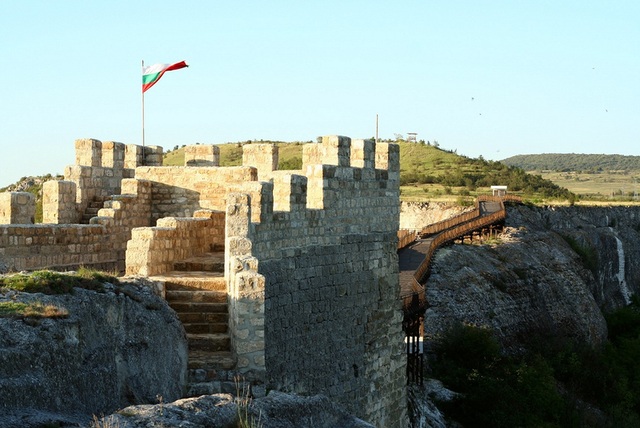
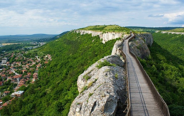
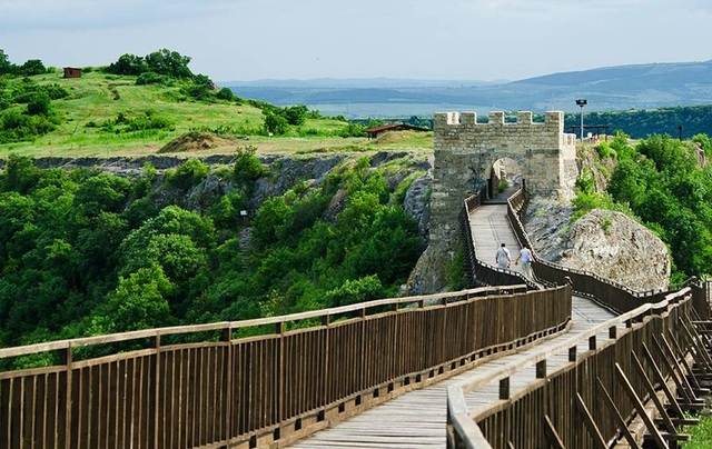
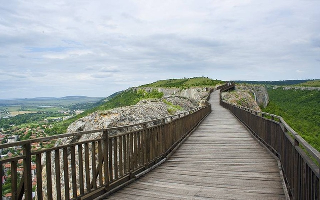
Ovech is situated on a mountain plateau named "Kaleto". It is ship-shaped and its head points south. It is surrounded from each side by 20 m high rocks. A narrow isthmus connects it to another plateau - Tabiite /the fortifications/ located north of "Kaleto".
history
The fortress is known with several names in the historical annals. The oldest of them is Provat. Bulgarians call it Ovech and the Turks Tash hisar /translated from Turkish - stone fortress/. Archaelogical researches show that the fort was used from III century till the first decades of VII century and after thata from X-XI century till the end of XVII century.
The fort has been inhabited successively by Thracians, Romans, Byzantines, Bulgarians and Turks. Its name is associated with the reign of Tsar Ivaylo (1277 - 1280), with the march of Count Amadeus VI of Savoy (1366) and the march of the Polish-Hungarian king Vladislav III Jagiello (Varnenchik) (1444). At first the fort had only defensive functions but it became a major administrative and military center very fast. Later Ovech became the primary barrier against the invading troops towards Pliska, Preslav and Veliko Tarnovo.
Ovech fort acquired strategic importance during the Second Bulgarian Kingdom when it became an important administrative, cultural, religious and military center.
In 1366 by the order of Tsar Ivan Alexander the knights of Amadeus of Savoy the Sixth, captured during the unsuccessful siege of Varna, were thrown in the fort. Ovech was conquered by the troops of Ali Pasha in 1388 and it was then when it received its Turkish name. There was another twist in the history of the castle, as it goes back into Bulgarian hands for a short time once again. In 1414 the son of Bayazid - Musa conquered Ovech again. During the crusade of Vladyslav III Jagiello of Varna in 1444 the fort was captured and destroyed.
architecture
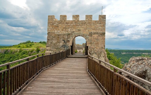
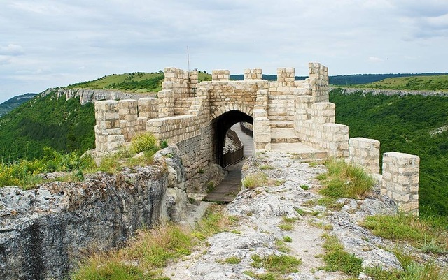
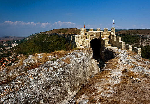
The fortress has three entrances:
- the eastern approach is preserved in its original version with stone stairs cut in the rock. It is convenient for visitors with private transport.
- the west entrance is accessible from the town via an original spiral staircase with 111 steps.
- the northern entrance is the main one. It has a 150 m long bridge in front of it that connects the fortress to the neighbouring plateau - Tabiite.
When visiting the castle in stone fort you can also see the speaking well, 79 meters deep, the metropolitan church, the knight's prison, the tower with the devil path and the monk holes.
The fort is open all-year-round. There is a guide provided by Provadiya Historical Museum. Information materials and souvenirs are sold on the spot.
transport
The Ovech fortress is easily reachable since it is situated in the outskirts of the town of Provadiya.
accomodation
Visistors can take advanatage of one family hotel complex in Provadiya as well as of one guest house in the village of Barzitsa /15 km in the south-east/.
Sources: http://bulgariatravel.org, http://bg.wikipedia.org, http://www.bulgariainside.com
Photos: http://bg.wikipedia.org, http://bulgariatravel.org

Chuprene Biosphere Reserve
The reserve is one of the largest biosphere reserves in Bulgaria. It is established in 1973 to preserve the northern coniferous forests of Bulgaria. In 1977 it was included in the list of biosphere reserves under the program "Man and Biosphere".
See on the map
Water Holes Cave
Water Holes Cave is located in Apriltsi Municipality, within the Central Balkan National Park on the northern slope of the massif of Botev Mount.
See on the map
Albotin rock monastery
Albotin monastery is an inactive Medieval rock monastery included in Vidin diocese.
See on the map
Uzana - the geographic center of Bulgaria
Uzana - the heart of the Balkans. In its embrace, the mountains has kept this extraordinary place where you can fully take charge with power and hours to enjoy its grandeur and beauty of nature.Far from the urban vanity you will find abundance of colors and shades, serenity and peace of mind. Here the warbling of the birds and the whisper of wild grasslands will put a spell on you forever.

Chervenitsa - geological phenomena over the village of Kunino
The natural phenomenon Chervenitsa is a molded boulder, rising more than 150 m above the terrace of the river Iskar in village of Kunino. It is located about 46 km east of Vratsa and approximately 120 km northeast of Sofia.
See on the map
The museum of salt
A unique museum in the whole Eastern Europe dedicated to the production of salt by solar evaporation of sea water, Pomorie
See on the map
Lopushanski monastery "Sv. Yoan Predtecha"
The Lopushanski monastery is located in the Balkan Mountain in the valley of Dalgodelska Ogosta river. It is operational and consists of a church, residential and farm buildings and a white stone fountain, all surrounded by a stone wall.
See on the map
Taukliman Reserve
Natural Reserve Taukliman typical landslide with length of about 4 km, formed between the edge of the Dobrudzhansko plateau and the coast.

Basilica Sveta Sofia - Sofia city
The Early Christian basilica Sveta Sofia is an active Orthodox church in the center of Sofia city. The church was probably built in the early VI century on the ruins of early Christian tombs from II - IV century and the ruins of two earlier churches from IV-V century. It is located among the necropolis of the ancient Serdica.
See on the map
Medieval fortress "Monyak"
"Monyak" fortress is one of the largest and high located fortresses in the Rhodopes near the village of Shiroko pole, Kardzhali Region
See on the map
Vakarelski monastery "St Petka"
Vakarelski monastery "St Petka" was found in XX century and now it is working occasionally. It was functioning as nunnery.
See on the map
"The Womb" cave
A unique Thracian temple near the village of Nenkovo, Kardzhali Region
See on the map
Thracian sanctuary "Gluhite kamani"
The megalithic complex "Gluhite kamani" is one of the largest Thracian sanctuaries since BC, whose strength continues to act today to anyone who visits it.
See on the map
Krivus Fortress
A medieval fortress located on a picturesque cliff above Arda River near the village of Bashevo, Kardzhali Region
See on the map
"St. Konstantin and Elena" monastery near Ladzha quarter, Ivaylovgrad
The monastery of Lazdha or Ivaylovrad monastery "St. Konstantin and Elena" is situated close to Ladzha quarter in the town of Ivaylovgrad
See on the map
Rakovitsa monastery Sveta Troitsa
Rakovitsa monastery Sveta Troitsa was was found in X-XI century and during the Middle Ages was an important literary and cultural center in Bdin area.
See on the map
Roman tomb - town of Hisarya
The Hisar tomb is a late Roman family tomb built in the second half of the IV-th century.
See on the map
Elenska basilica
Elenska basilica is early Christian temple that is preserved to nowadays and is situated in proximity to the town of Pirdop
See on the map
"St. Theodor Tyron and Theodor Stratilat" church
A unique monument of culture with extremely precious frescoes and icons included in UNESCO's list with the World Cultural Heritage, village of Dobarsko, Blagoevgrad Region
See on the map
Momina kula Fort
Late ancient and medieval fortress in the Pirin mountain part of Mesta River in the settlement of the village of Kremen
See on the map