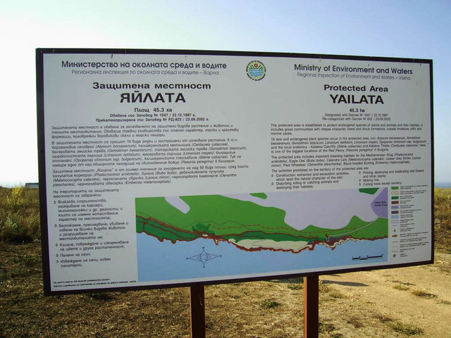
Yailata resort
See on the map

Location
Yailata is a national archaeological reserve located 2 km south of Kamen Bryag village, 18 km east of Kavarna town, around 80 km northeast of Varna city and approximately 525 km northeast of Sofia city.
Reserve
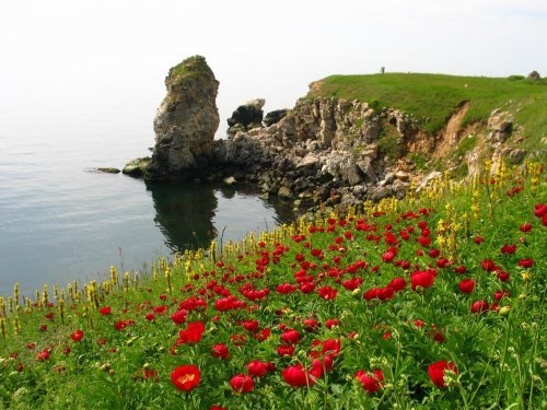
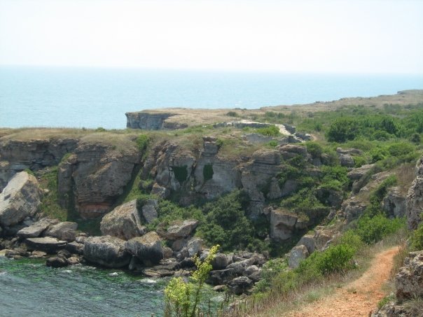
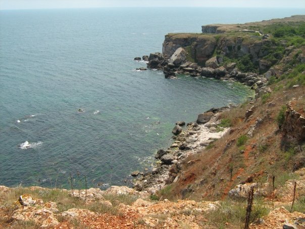
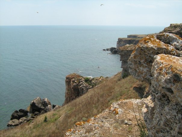
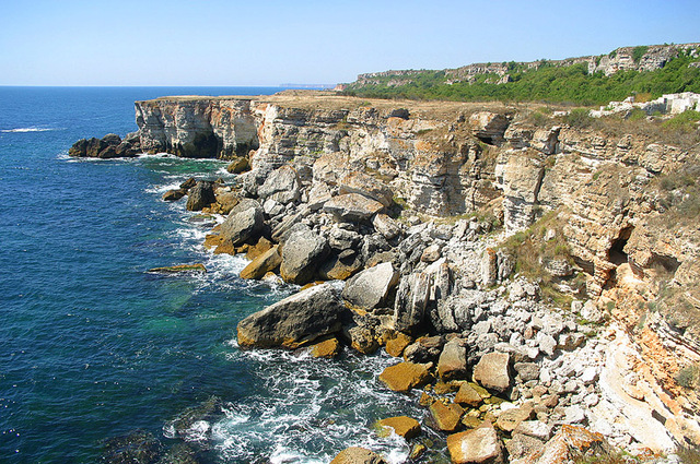
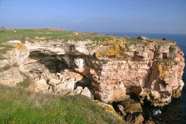
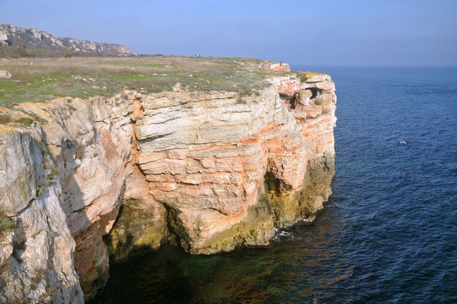
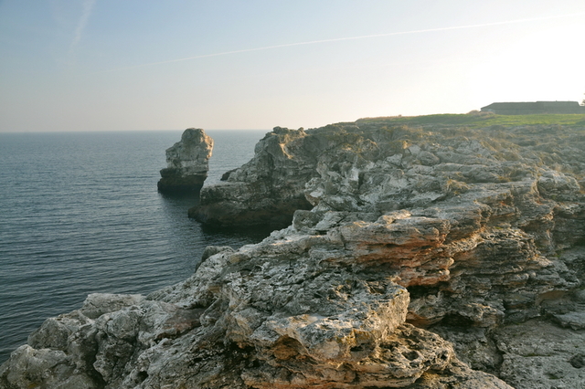
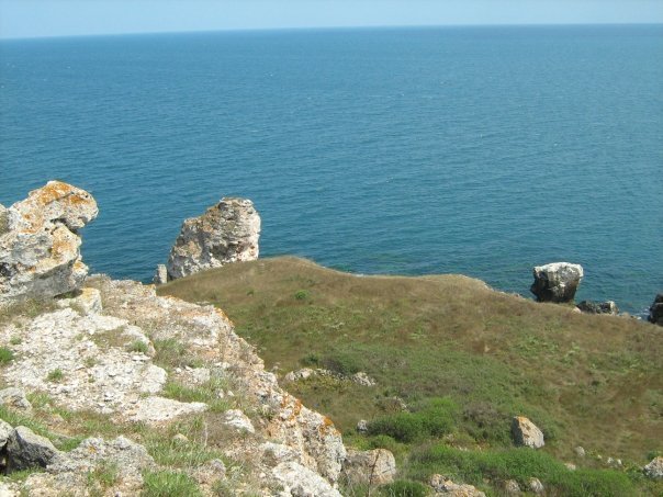
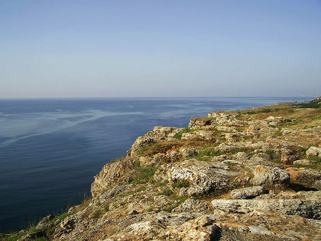
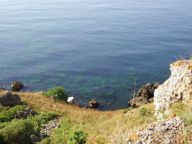
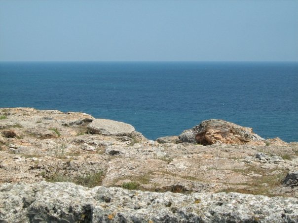
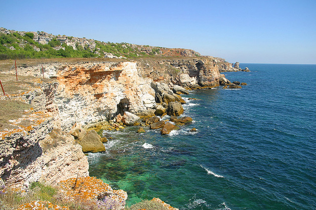
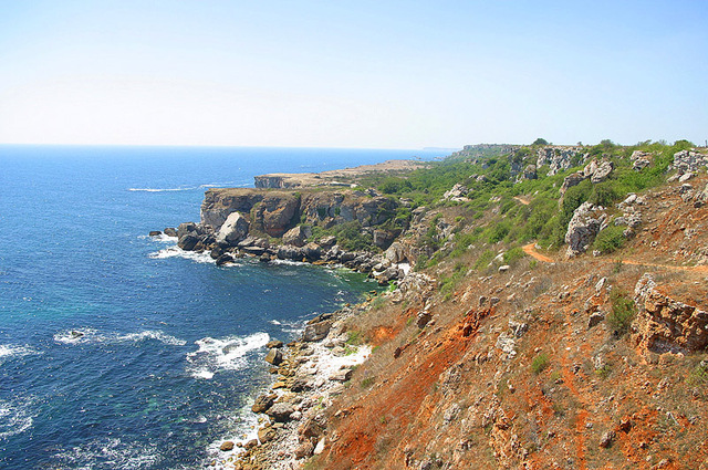
It is a seaside terrace with an area of around 3000 acres, separated from the sea by 50 to 60 m high cliffs. The reserve begins north of Kamen Bryag village, reaches south to Rusalka resort and includes 500 m wide strip of land along the shore.
The name 'Yaila' is Turkish and means 'high pasture'.
Both terraces of the reserve (The Large and The Small Yaila) are separated by a small bay. Locals called it Ashalaka, which in Turkish means 'the place at the bottom'. Depths of the bay almost reach the foot of the Dobrudzha plateau, and in the past has been a port.
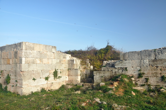
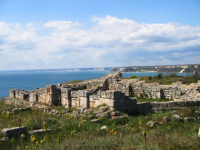
On the territory of the archaeological complex are numerous monuments belonging to different historical periods, from the VI century BC to the mid XI century AD.
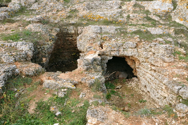
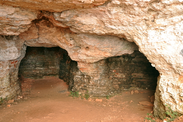
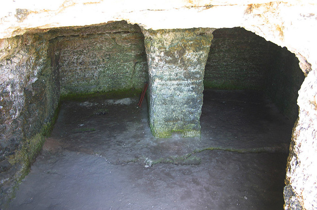
caves
A large number of caves are located in the reserve. They are carved by hand, single or grouped into complexes. Only in the Big Yaila they are 101, but inaccessible. For several years speleologists, surveyors and technicians performed their full documentation. The caves are located at several levels in the vertical slopes, limiting the area toward the Dobrudzha plateau and the sea. They were used over thousands of years as dwellings and some of them as tombs or churches. During the Early Byzantine period - V - VI century they served as monastic cloister, i.e. it was one of the so called rock monasteries in Dobrudzha.
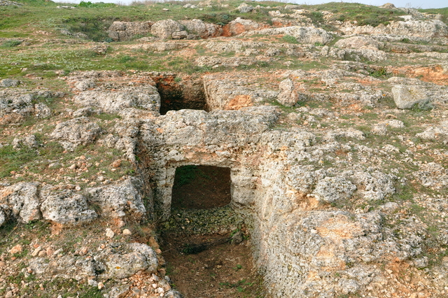
Rock Necropolises
Over 120 burial discovered three facilities in the necropolis of III - V century in reserve. They are carved into the rocky plateau or plain precipitous slopes. In southern terrace Yaylenskata explored several tombs called. Caving type which is composed of small halls in which to enter into a rectangular burial chamber.
More systematically studied Necropolis № 1, which is located on the crown of a towering 50-60 meters above sea rocky shore.
With few exceptions, almost all tombs were robbed in antiquity or modern times. Find the grave inventory - clay bowls, pots, bowls, bronze and iron buckles, glass beads, coins and other dating them in chronological limits of II - V century. The tombs were family, have worked a long time in some of them are open 15 skeletons.
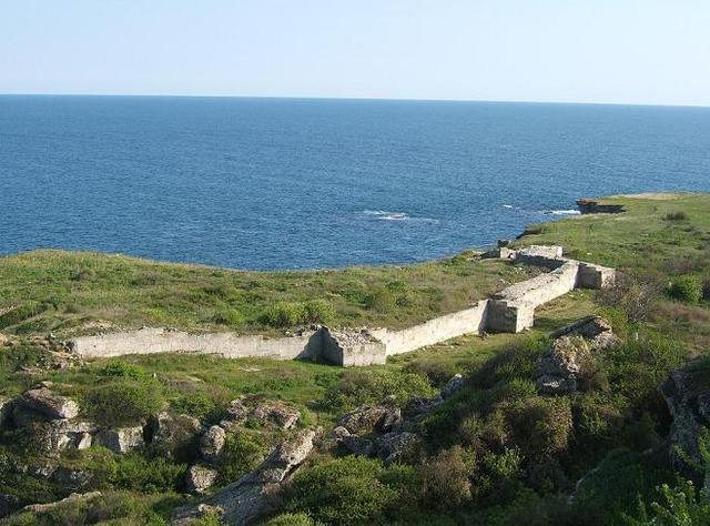
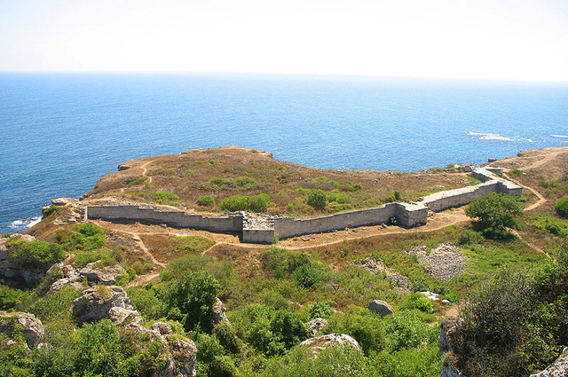
Fortress
In the northern part of the plane terrace etc. Much Yaila can see the remains of early Byzantine fortress built during the reign of Emperor Anastasius - V-VI century, with a total area of 2.5 acres. Are preserved traces of five towers, three stairs and a gate tower, destroyed in the VI century.
Nature
Yailata not only kept interesting and important cultural and historical monuments, but also a unique natural phenomenon. Varied flora and fauna.
Here goes Via Pontica - one of the main migration routes for migratory birds. Twice a year at this point can be observed migration of the 174 species of birds, 50 species of which nest in the cliffs of the reserve. Yailata Caves caves are inhabited by pigeons and bats. Shag, lapwing and Roller also considered "high pasture" for their home. There are also rare in Europe and the polecat Newtonian hamster. In the past, the lower caves were inhabited by monk seals.
The total number of animals registered in Yailata over 270. There are also 19 species of rare and endangered plants.
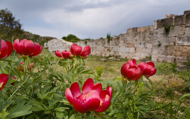
Yailata is especially beautiful in spring and autumn. Blooming irises, peonies and cornflowers.
If you like archeology, nature lovers and keen ornithologist or just have access to the sea near Yailata, necessarily visit the reserve. Definitely something to see there.
Transport
The reserve is easily accessible from Varna on the road E87 in the direction of Kavarna. In Kavarna is taken by road to 901 Kamen Beach. At the outset of the village has the right and exit sign Yailata. At the entrance of the reserve's parking lot. Distance from the village there can be traveled on foot.
Accommodation
Kamen Beach Village offers apartments and hotel rooms. Again there can eat delicious local dishes.
Sources: http://kavarnamuseum.org; http://kamenbryag.info; http://forvacation.blogspot.com;
Photos: Mirela, Internet.

Chuprene Biosphere Reserve
The reserve is one of the largest biosphere reserves in Bulgaria. It is established in 1973 to preserve the northern coniferous forests of Bulgaria. In 1977 it was included in the list of biosphere reserves under the program "Man and Biosphere".
See on the map
Water Holes Cave
Water Holes Cave is located in Apriltsi Municipality, within the Central Balkan National Park on the northern slope of the massif of Botev Mount.
See on the map
Albotin rock monastery
Albotin monastery is an inactive Medieval rock monastery included in Vidin diocese.
See on the map
Uzana - the geographic center of Bulgaria
Uzana - the heart of the Balkans. In its embrace, the mountains has kept this extraordinary place where you can fully take charge with power and hours to enjoy its grandeur and beauty of nature.Far from the urban vanity you will find abundance of colors and shades, serenity and peace of mind. Here the warbling of the birds and the whisper of wild grasslands will put a spell on you forever.

Chervenitsa - geological phenomena over the village of Kunino
The natural phenomenon Chervenitsa is a molded boulder, rising more than 150 m above the terrace of the river Iskar in village of Kunino. It is located about 46 km east of Vratsa and approximately 120 km northeast of Sofia.
See on the map
The museum of salt
A unique museum in the whole Eastern Europe dedicated to the production of salt by solar evaporation of sea water, Pomorie
See on the map
Lopushanski monastery "Sv. Yoan Predtecha"
The Lopushanski monastery is located in the Balkan Mountain in the valley of Dalgodelska Ogosta river. It is operational and consists of a church, residential and farm buildings and a white stone fountain, all surrounded by a stone wall.
See on the map
Taukliman Reserve
Natural Reserve Taukliman typical landslide with length of about 4 km, formed between the edge of the Dobrudzhansko plateau and the coast.

Basilica Sveta Sofia - Sofia city
The Early Christian basilica Sveta Sofia is an active Orthodox church in the center of Sofia city. The church was probably built in the early VI century on the ruins of early Christian tombs from II - IV century and the ruins of two earlier churches from IV-V century. It is located among the necropolis of the ancient Serdica.
See on the map
Medieval fortress "Monyak"
"Monyak" fortress is one of the largest and high located fortresses in the Rhodopes near the village of Shiroko pole, Kardzhali Region
See on the map
Vakarelski monastery "St Petka"
Vakarelski monastery "St Petka" was found in XX century and now it is working occasionally. It was functioning as nunnery.
See on the map
"The Womb" cave
A unique Thracian temple near the village of Nenkovo, Kardzhali Region
See on the map
Thracian sanctuary "Gluhite kamani"
The megalithic complex "Gluhite kamani" is one of the largest Thracian sanctuaries since BC, whose strength continues to act today to anyone who visits it.
See on the map
Krivus Fortress
A medieval fortress located on a picturesque cliff above Arda River near the village of Bashevo, Kardzhali Region
See on the map
"St. Konstantin and Elena" monastery near Ladzha quarter, Ivaylovgrad
The monastery of Lazdha or Ivaylovrad monastery "St. Konstantin and Elena" is situated close to Ladzha quarter in the town of Ivaylovgrad
See on the map
Rakovitsa monastery Sveta Troitsa
Rakovitsa monastery Sveta Troitsa was was found in X-XI century and during the Middle Ages was an important literary and cultural center in Bdin area.
See on the map
Roman tomb - town of Hisarya
The Hisar tomb is a late Roman family tomb built in the second half of the IV-th century.
See on the map
Elenska basilica
Elenska basilica is early Christian temple that is preserved to nowadays and is situated in proximity to the town of Pirdop
See on the map
"St. Theodor Tyron and Theodor Stratilat" church
A unique monument of culture with extremely precious frescoes and icons included in UNESCO's list with the World Cultural Heritage, village of Dobarsko, Blagoevgrad Region
See on the map
Ovech Fortress
One of the oldest fortresses in Bulgaria located on a high mountain plateau above the town of Provadiya
See on the map