Thracian medieval fortress "Vishegrad"
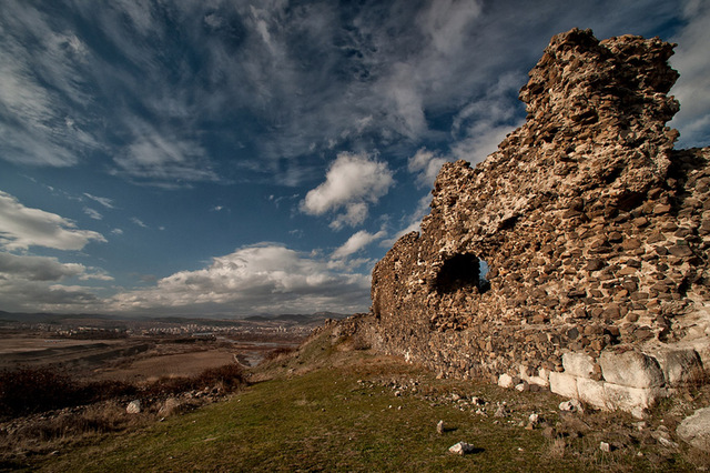
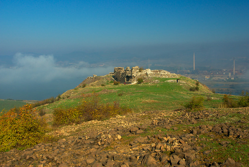

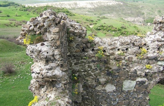
The fortress "Vishegrad" is situated on a high hill on the right bank of the Arda River in the area Harman Kaya, next to the village with the same name in the close proximity of Kardzhali. It is located at about 8 km south-east of the town of Kardzhali, 15 km north of Momchilgrad, 252 km south of Bourgas and 249 km south-east of the capital Sofia city.
The name of the fortress has Slavonic origins and means "high town" - a name which used to be given to forts in other Slavonic countries as well. The fortress is known among the local population as Hissar Yustyu (Upper fortress).
The ancient Thracian fortress dates back from the IV century BC. – I century AD. Its area is relatively small (562 sq.m) and according to the structure and its size it was probably a medieval feudal castle - most likely the residence of the Governor of the Ahridos area. The fortress was used to control the main road passing through the region.
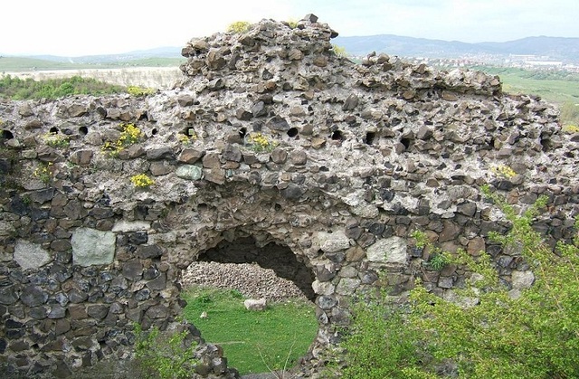
The fortress is situated on a hill called "Kamenen harman”. Its walls reuse the foundations of an earlier fortress built in the Antique. Only few places are available from the east, south and west and the north side is protected by an arch-shaped wall extended at the west end. During the excavations that were made in 1971 - 1974, the fortifying wall and the inside of the fortress were cleared up.
The wall is approximately 2 m thick and about 1 m high. It was built of rough stones cemented with mud and in some places the joints were filled with small pebbles and dirt. The entrance to the fort is located at its eastern end, it is about 2 m wide.
Bases of furnaces were found at several places inside the fortress. The excavations revealed another grinder, fragments of pottery, iron tools and weapons. The earliest material dates back to the transition between the Old-Iron and the Bronze age. It is believed that life continued in the ancient and medieval periods.
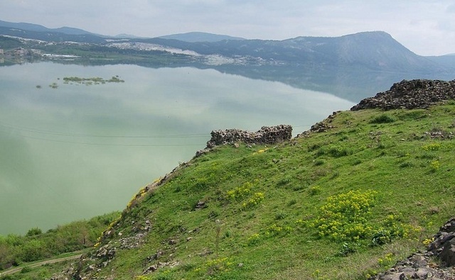
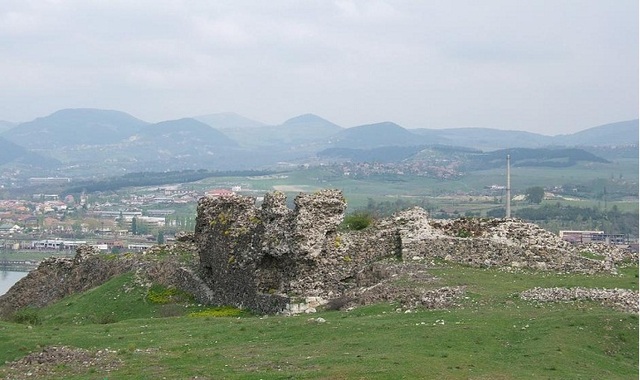
The “Vishegrad” fortress has a direct visual connection with the Monyak Fortress near the village of Shiroko pole located on the opposite bank of the dam. Furthermore, the fortress offers a magnificent view to one of the most picturesque dams in the Eastern Rhodopes – the Studen Kladenets dam which offers excellent conditions for fishing and water sports.
transport and accomodation
The fortress is easily accessible and convenient to visit. It can be reached via a relatively good dirt road starting from the village of Vishegrad. Several hotels, villas and guest houses, holiday homes and restaurants are available for tourists in the town of Kardzhali.
Source: www.kardjali.bg, www.rhodopes-gallery.com
Photos: www.tourism.kardzhali.bg

Chuprene Biosphere Reserve
The reserve is one of the largest biosphere reserves in Bulgaria. It is established in 1973 to preserve the northern coniferous forests of Bulgaria. In 1977 it was included in the list of biosphere reserves under the program "Man and Biosphere".
See on the map
Water Holes Cave
Water Holes Cave is located in Apriltsi Municipality, within the Central Balkan National Park on the northern slope of the massif of Botev Mount.
See on the map
Albotin rock monastery
Albotin monastery is an inactive Medieval rock monastery included in Vidin diocese.
See on the map
Uzana - the geographic center of Bulgaria
Uzana - the heart of the Balkans. In its embrace, the mountains has kept this extraordinary place where you can fully take charge with power and hours to enjoy its grandeur and beauty of nature.Far from the urban vanity you will find abundance of colors and shades, serenity and peace of mind. Here the warbling of the birds and the whisper of wild grasslands will put a spell on you forever.

Chervenitsa - geological phenomena over the village of Kunino
The natural phenomenon Chervenitsa is a molded boulder, rising more than 150 m above the terrace of the river Iskar in village of Kunino. It is located about 46 km east of Vratsa and approximately 120 km northeast of Sofia.
See on the map
The museum of salt
A unique museum in the whole Eastern Europe dedicated to the production of salt by solar evaporation of sea water, Pomorie
See on the map
Lopushanski monastery "Sv. Yoan Predtecha"
The Lopushanski monastery is located in the Balkan Mountain in the valley of Dalgodelska Ogosta river. It is operational and consists of a church, residential and farm buildings and a white stone fountain, all surrounded by a stone wall.
See on the map
Taukliman Reserve
Natural Reserve Taukliman typical landslide with length of about 4 km, formed between the edge of the Dobrudzhansko plateau and the coast.

Basilica Sveta Sofia - Sofia city
The Early Christian basilica Sveta Sofia is an active Orthodox church in the center of Sofia city. The church was probably built in the early VI century on the ruins of early Christian tombs from II - IV century and the ruins of two earlier churches from IV-V century. It is located among the necropolis of the ancient Serdica.
See on the map
Medieval fortress "Monyak"
"Monyak" fortress is one of the largest and high located fortresses in the Rhodopes near the village of Shiroko pole, Kardzhali Region
See on the map
Vakarelski monastery "St Petka"
Vakarelski monastery "St Petka" was found in XX century and now it is working occasionally. It was functioning as nunnery.
See on the map
"The Womb" cave
A unique Thracian temple near the village of Nenkovo, Kardzhali Region
See on the map
Thracian sanctuary "Gluhite kamani"
The megalithic complex "Gluhite kamani" is one of the largest Thracian sanctuaries since BC, whose strength continues to act today to anyone who visits it.
See on the map
Krivus Fortress
A medieval fortress located on a picturesque cliff above Arda River near the village of Bashevo, Kardzhali Region
See on the map
"St. Konstantin and Elena" monastery near Ladzha quarter, Ivaylovgrad
The monastery of Lazdha or Ivaylovrad monastery "St. Konstantin and Elena" is situated close to Ladzha quarter in the town of Ivaylovgrad
See on the map
Rakovitsa monastery Sveta Troitsa
Rakovitsa monastery Sveta Troitsa was was found in X-XI century and during the Middle Ages was an important literary and cultural center in Bdin area.
See on the map
Roman tomb - town of Hisarya
The Hisar tomb is a late Roman family tomb built in the second half of the IV-th century.
See on the map
Elenska basilica
Elenska basilica is early Christian temple that is preserved to nowadays and is situated in proximity to the town of Pirdop
See on the map
"St. Theodor Tyron and Theodor Stratilat" church
A unique monument of culture with extremely precious frescoes and icons included in UNESCO's list with the World Cultural Heritage, village of Dobarsko, Blagoevgrad Region
See on the map
Ovech Fortress
One of the oldest fortresses in Bulgaria located on a high mountain plateau above the town of Provadiya
See on the map