Erma River Gorge
See on the map

Erma River Gorge (Lomnishkoto Gorge) is a breach on Erma river that is located about 4 km from the town of Tran. It is the biggest touristic sight in Tran region and is in the list of the 100 Tourist Sites of Bulgaria.
It is 50 km northwest of the town of Pernik and 79 km in the same direction from Sofia.
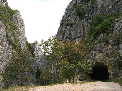
The access to the Gorge is through an asphalt road from the town of Tran. From the south end of the Gorge begins the Tran route with length 13 km. It is with altitude from 600 to 1000 m. The route takes 8 hours. During this march you will pass trough small wooden bridge, gravel road with interesting tunnel and another wooden bridge. Meanwhile you will enjoy the gorgeous scenery, the incredible nature and in the end the magnificent view to the Erma River Gorge.
Another starting point for this route is the village of Bankya which is situated in proximity to the Yablanitsa Gorge. This route is much more difficult and is recommendable to be taken during the summer after May. The route consists of series of flat areas, steep ascents and descents, bridges and stairs.
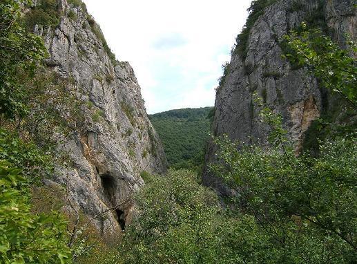
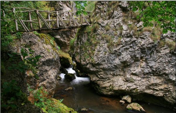
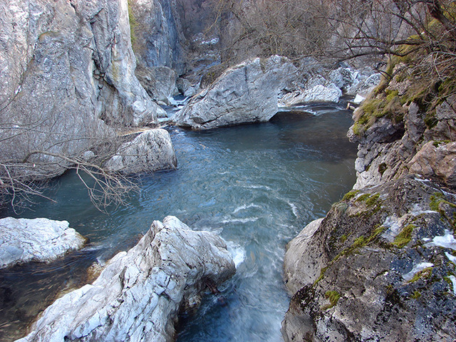
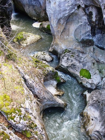
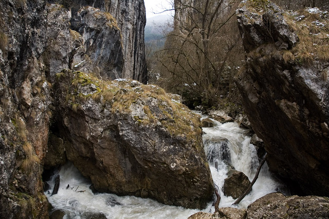
The length of the whole Erma River Gorge is about 100 meters and its width in the narrowest sections is about 5 m. Sideways are the steep rocks of Zhilav kamak on the south and Tsarkvishteto on the north. In the highest sections the vertical rocks are up to 150-200 meters. The river is not deep but passes noisily through the rock formations. On the right shore of the Gorge is built artificial tunnel which leads the village of Bankya. Above the twisting route are constructed two bridges that cross the river from both sides of the Gorge.
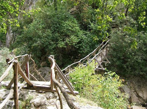
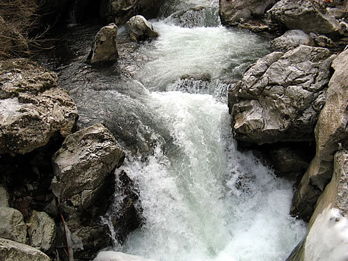
In the lowest part on level of the river the distance between the two rocks is just 3-4 m. In this narrow section there is one 4 meter high waterfall and along the shore of the river there are many massive rocks, entrances of karst caves, waterworks and waterfalls. Just in this section there is hanging wooden bridge which is part of the route and the view is unique.
There are legends and folktales about how is the gorge formatted. According to one of them these are two lovers and because their love was forbidden they were turned into stones (rocks). And that's how the destiny decided for them to be just a few meters away from each other and never to meet. The Erma river appeared from their teardrops.
The rocks of Erma River Gorge are starting point for over ten alpine routes which makes the place destination for professional and amateur climbers.
The town of Tran offers the tourists option for accommodation
Sources: http://www.tourism-bg.net http://pochivka.com
Photos: internet

Chuprene Biosphere Reserve
The reserve is one of the largest biosphere reserves in Bulgaria. It is established in 1973 to preserve the northern coniferous forests of Bulgaria. In 1977 it was included in the list of biosphere reserves under the program "Man and Biosphere".
See on the map
Water Holes Cave
Water Holes Cave is located in Apriltsi Municipality, within the Central Balkan National Park on the northern slope of the massif of Botev Mount.
See on the map
Albotin rock monastery
Albotin monastery is an inactive Medieval rock monastery included in Vidin diocese.
See on the map
Uzana - the geographic center of Bulgaria
Uzana - the heart of the Balkans. In its embrace, the mountains has kept this extraordinary place where you can fully take charge with power and hours to enjoy its grandeur and beauty of nature.Far from the urban vanity you will find abundance of colors and shades, serenity and peace of mind. Here the warbling of the birds and the whisper of wild grasslands will put a spell on you forever.

Chervenitsa - geological phenomena over the village of Kunino
The natural phenomenon Chervenitsa is a molded boulder, rising more than 150 m above the terrace of the river Iskar in village of Kunino. It is located about 46 km east of Vratsa and approximately 120 km northeast of Sofia.
See on the map
The museum of salt
A unique museum in the whole Eastern Europe dedicated to the production of salt by solar evaporation of sea water, Pomorie
See on the map
Lopushanski monastery "Sv. Yoan Predtecha"
The Lopushanski monastery is located in the Balkan Mountain in the valley of Dalgodelska Ogosta river. It is operational and consists of a church, residential and farm buildings and a white stone fountain, all surrounded by a stone wall.
See on the map
Taukliman Reserve
Natural Reserve Taukliman typical landslide with length of about 4 km, formed between the edge of the Dobrudzhansko plateau and the coast.

Basilica Sveta Sofia - Sofia city
The Early Christian basilica Sveta Sofia is an active Orthodox church in the center of Sofia city. The church was probably built in the early VI century on the ruins of early Christian tombs from II - IV century and the ruins of two earlier churches from IV-V century. It is located among the necropolis of the ancient Serdica.
See on the map
Medieval fortress "Monyak"
"Monyak" fortress is one of the largest and high located fortresses in the Rhodopes near the village of Shiroko pole, Kardzhali Region
See on the map
Vakarelski monastery "St Petka"
Vakarelski monastery "St Petka" was found in XX century and now it is working occasionally. It was functioning as nunnery.
See on the map
"The Womb" cave
A unique Thracian temple near the village of Nenkovo, Kardzhali Region
See on the map
Thracian sanctuary "Gluhite kamani"
The megalithic complex "Gluhite kamani" is one of the largest Thracian sanctuaries since BC, whose strength continues to act today to anyone who visits it.
See on the map
Krivus Fortress
A medieval fortress located on a picturesque cliff above Arda River near the village of Bashevo, Kardzhali Region
See on the map
"St. Konstantin and Elena" monastery near Ladzha quarter, Ivaylovgrad
The monastery of Lazdha or Ivaylovrad monastery "St. Konstantin and Elena" is situated close to Ladzha quarter in the town of Ivaylovgrad
See on the map
Rakovitsa monastery Sveta Troitsa
Rakovitsa monastery Sveta Troitsa was was found in X-XI century and during the Middle Ages was an important literary and cultural center in Bdin area.
See on the map
Roman tomb - town of Hisarya
The Hisar tomb is a late Roman family tomb built in the second half of the IV-th century.
See on the map
Elenska basilica
Elenska basilica is early Christian temple that is preserved to nowadays and is situated in proximity to the town of Pirdop
See on the map
"St. Theodor Tyron and Theodor Stratilat" church
A unique monument of culture with extremely precious frescoes and icons included in UNESCO's list with the World Cultural Heritage, village of Dobarsko, Blagoevgrad Region
See on the map
Ovech Fortress
One of the oldest fortresses in Bulgaria located on a high mountain plateau above the town of Provadiya
See on the map