National park Sinite kamani
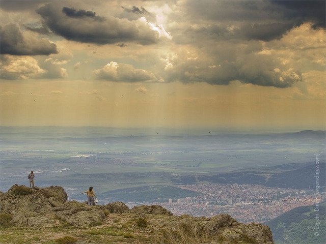
The legend tells that the natural formation Sinite kamani (Blue Stones), in the eastern part of the Balkans Mountain, was formed by the ancient Greek gods Zeus and Herat. Later, the mortals liked the gods' creation and decided to build their settlement in the valley. There are a lot of legends like this one for the national park Sinite kamani. The park is situated on the road that connects the capital with the Black sea.
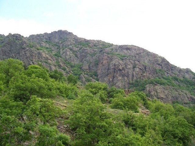
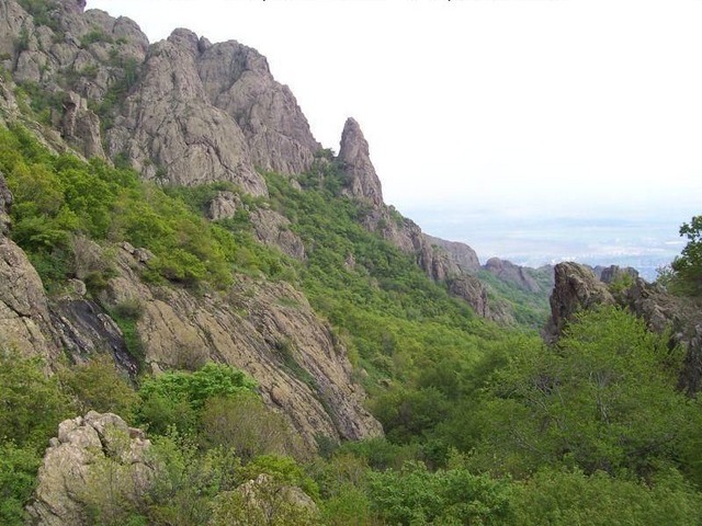
The national park is located on the southern slopes of the Balkans Mountain. Its square surface is about 11 400 sq.m. and is part of the protected areas in the country.
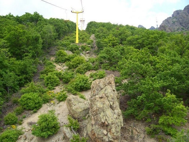
When the rocks reflect the sun light on a definite angel, their colour changes to blue. This is the reason of their name Blue Stones. There are three urbanized recreation zones in the park. The most famous is Karandila. Karan means healthy place. From the ancient times the place is known for its healing effect on ill people.
The other recreation zone is Daula. The most eastern ski-run in Bulgaria is situated there. It attracts a lot of tourists during the seasons. The third place - Selishteto, is in close proximity to city of Sliven (about 4 - 5km). It is a villa zone, located in the south part of the park. There is the path of health which is just perfect for walks of handicapped people.
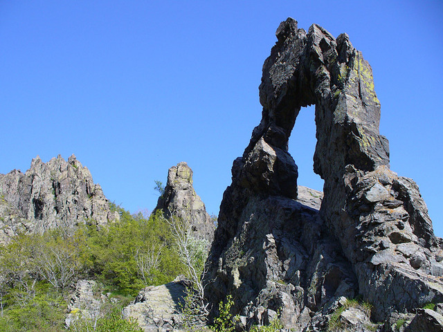
The symbol of Sliven city is the rock formation - Halkata. It can be seen in all park's ads.
Sinite kamani is famous with its priceless archaeological monuments. Remains from medieval fortresses and monasteries can be seen here. The mountainous relief of the park makes it suitable for exercising almost all types of mountain sports - skiing, alpinism, rock-climbing, cycling, mountain cycling, hang-gliding, parachutism, gliding, as well as route and cognitive tourism. Great biodiversity is to be found within the park. The existing tourist tracks on the territory of the park are more than 50, while the main tourist routes, leading to different destinations are 18. Karandila locality is the most visited part of the mountain.
Most people consider that Sinite kamani is the most beautiful and romantic part of the eastern Balkans. For more information do not forget to visit the Information visitors' centre of the park. You can look at the routes and natural landmarks in the park; get some maps, guide-books and books for the national park Sinite kamani.

Chuprene Biosphere Reserve
The reserve is one of the largest biosphere reserves in Bulgaria. It is established in 1973 to preserve the northern coniferous forests of Bulgaria. In 1977 it was included in the list of biosphere reserves under the program "Man and Biosphere".
See on the map
Water Holes Cave
Water Holes Cave is located in Apriltsi Municipality, within the Central Balkan National Park on the northern slope of the massif of Botev Mount.
See on the map
Albotin rock monastery
Albotin monastery is an inactive Medieval rock monastery included in Vidin diocese.
See on the map
Uzana - the geographic center of Bulgaria
Uzana - the heart of the Balkans. In its embrace, the mountains has kept this extraordinary place where you can fully take charge with power and hours to enjoy its grandeur and beauty of nature.Far from the urban vanity you will find abundance of colors and shades, serenity and peace of mind. Here the warbling of the birds and the whisper of wild grasslands will put a spell on you forever.

Chervenitsa - geological phenomena over the village of Kunino
The natural phenomenon Chervenitsa is a molded boulder, rising more than 150 m above the terrace of the river Iskar in village of Kunino. It is located about 46 km east of Vratsa and approximately 120 km northeast of Sofia.
See on the map
Lopushanski monastery "Sv. Yoan Predtecha"
The Lopushanski monastery is located in the Balkan Mountain in the valley of Dalgodelska Ogosta river. It is operational and consists of a church, residential and farm buildings and a white stone fountain, all surrounded by a stone wall.
See on the map
The museum of salt
A unique museum in the whole Eastern Europe dedicated to the production of salt by solar evaporation of sea water, Pomorie
See on the map
Taukliman Reserve
Natural Reserve Taukliman typical landslide with length of about 4 km, formed between the edge of the Dobrudzhansko plateau and the coast.

Basilica Sveta Sofia - Sofia city
The Early Christian basilica Sveta Sofia is an active Orthodox church in the center of Sofia city. The church was probably built in the early VI century on the ruins of early Christian tombs from II - IV century and the ruins of two earlier churches from IV-V century. It is located among the necropolis of the ancient Serdica.
See on the map
Medieval fortress "Monyak"
"Monyak" fortress is one of the largest and high located fortresses in the Rhodopes near the village of Shiroko pole, Kardzhali Region
See on the map
Vakarelski monastery "St Petka"
Vakarelski monastery "St Petka" was found in XX century and now it is working occasionally. It was functioning as nunnery.
See on the map
"The Womb" cave
A unique Thracian temple near the village of Nenkovo, Kardzhali Region
See on the map
Thracian sanctuary "Gluhite kamani"
The megalithic complex "Gluhite kamani" is one of the largest Thracian sanctuaries since BC, whose strength continues to act today to anyone who visits it.
See on the map
Krivus Fortress
A medieval fortress located on a picturesque cliff above Arda River near the village of Bashevo, Kardzhali Region
See on the map
"St. Konstantin and Elena" monastery near Ladzha quarter, Ivaylovgrad
The monastery of Lazdha or Ivaylovrad monastery "St. Konstantin and Elena" is situated close to Ladzha quarter in the town of Ivaylovgrad
See on the map
Rakovitsa monastery Sveta Troitsa
Rakovitsa monastery Sveta Troitsa was was found in X-XI century and during the Middle Ages was an important literary and cultural center in Bdin area.
See on the map
Roman tomb - town of Hisarya
The Hisar tomb is a late Roman family tomb built in the second half of the IV-th century.
See on the map
Elenska basilica
Elenska basilica is early Christian temple that is preserved to nowadays and is situated in proximity to the town of Pirdop
See on the map
"St. Theodor Tyron and Theodor Stratilat" church
A unique monument of culture with extremely precious frescoes and icons included in UNESCO's list with the World Cultural Heritage, village of Dobarsko, Blagoevgrad Region
See on the map
Ovech Fortress
One of the oldest fortresses in Bulgaria located on a high mountain plateau above the town of Provadiya
See on the map