Rock phenomenon "The Wonderful Rocks"
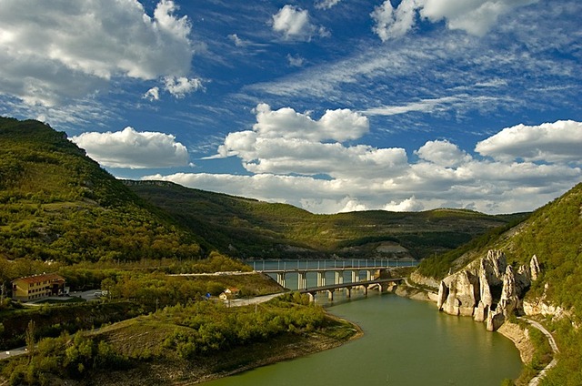


"The Wonderful rocks" is a rock phenomenon situated on the bank of Tsonevo Dam, 4 km of the village of Asparuhovo, Dalgopol municipality, Varna Region.
It is located at 16 km south-west of Dalgopol, 89 km in the same direction of the regionla center Varna, 57 km south-east of Shumen and about 406 km of the capital Sofia city.
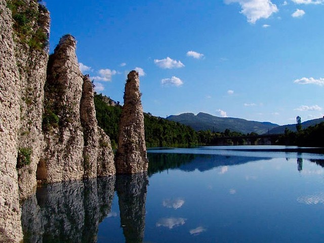
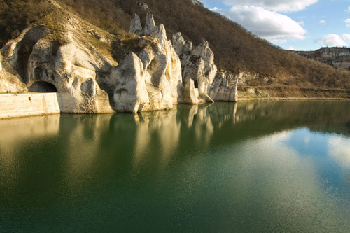
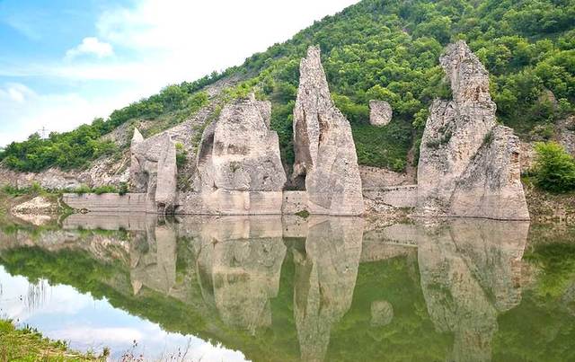
"The Wonderful rocks" represent a massif of about ten incredibly beautiful rock needles 40-50 m high, resembling castle towers. They were formed by the impact of wind and water on the limestone, making the rock not monolithic but in blocks. The rocks start right from the shores of the dam, where most of them are steep and precipitous. They have the shape of an arc with a characteristic ceiling in the upper part.
The phenomenon consists of three arrays, along their entire length there are three tunnels through which a road car made of rubble stones pass. Since they can be seen from the main road, the rocks often attract travelers who pull over to rest and enjoy the wonderful views and sculpted forms.
There are several caves, rocks and holes inhabited by large raptors in the region.The rocks equipped with climbing routes are also interesting. They are situated 5 minutes walking distance from the natural phenomenon, up a steep path at the place of an abandoned stone quarry.
"The Wonderful rocks" were declared a natural landmark in 1949.
transport
The main road connecting Prоvadia with Aytos is located in the close proximity of the phenomenon. The railroad Varna-Plovdiv is also close. If you stop on Asparuhovo station you can reach the rocks for about an hour. The asphalt road makes it possible for the rocks to be reached with a car - if you take the exit for the village of Asparuhovo without going in the village itself. You can see a sign for the landmark right before the exit in the left.
accomodation
Close to "The Wonderful Rocks" is situated the hut bearing the same name which has been transformed into two-star hotel and offers wonderful acoomodation conditions. The hut represents a three-storey building with 79 places, a restaurant and a refreshment room. The road is asphalt, there is a paring lot as well.
Sources: http://iseebg.com, http://pochivka.com/
Photos: http://zasveta.blogspot.com, http://www.p2pbg.com, http://www.panoramio.com

Chuprene Biosphere Reserve
The reserve is one of the largest biosphere reserves in Bulgaria. It is established in 1973 to preserve the northern coniferous forests of Bulgaria. In 1977 it was included in the list of biosphere reserves under the program "Man and Biosphere".
See on the map
Water Holes Cave
Water Holes Cave is located in Apriltsi Municipality, within the Central Balkan National Park on the northern slope of the massif of Botev Mount.
See on the map
Albotin rock monastery
Albotin monastery is an inactive Medieval rock monastery included in Vidin diocese.
See on the map
Uzana - the geographic center of Bulgaria
Uzana - the heart of the Balkans. In its embrace, the mountains has kept this extraordinary place where you can fully take charge with power and hours to enjoy its grandeur and beauty of nature.Far from the urban vanity you will find abundance of colors and shades, serenity and peace of mind. Here the warbling of the birds and the whisper of wild grasslands will put a spell on you forever.

Chervenitsa - geological phenomena over the village of Kunino
The natural phenomenon Chervenitsa is a molded boulder, rising more than 150 m above the terrace of the river Iskar in village of Kunino. It is located about 46 km east of Vratsa and approximately 120 km northeast of Sofia.
See on the map
The museum of salt
A unique museum in the whole Eastern Europe dedicated to the production of salt by solar evaporation of sea water, Pomorie
See on the map
Lopushanski monastery "Sv. Yoan Predtecha"
The Lopushanski monastery is located in the Balkan Mountain in the valley of Dalgodelska Ogosta river. It is operational and consists of a church, residential and farm buildings and a white stone fountain, all surrounded by a stone wall.
See on the map
Taukliman Reserve
Natural Reserve Taukliman typical landslide with length of about 4 km, formed between the edge of the Dobrudzhansko plateau and the coast.

Basilica Sveta Sofia - Sofia city
The Early Christian basilica Sveta Sofia is an active Orthodox church in the center of Sofia city. The church was probably built in the early VI century on the ruins of early Christian tombs from II - IV century and the ruins of two earlier churches from IV-V century. It is located among the necropolis of the ancient Serdica.
See on the map
Medieval fortress "Monyak"
"Monyak" fortress is one of the largest and high located fortresses in the Rhodopes near the village of Shiroko pole, Kardzhali Region
See on the map
Vakarelski monastery "St Petka"
Vakarelski monastery "St Petka" was found in XX century and now it is working occasionally. It was functioning as nunnery.
See on the map
"The Womb" cave
A unique Thracian temple near the village of Nenkovo, Kardzhali Region
See on the map
Thracian sanctuary "Gluhite kamani"
The megalithic complex "Gluhite kamani" is one of the largest Thracian sanctuaries since BC, whose strength continues to act today to anyone who visits it.
See on the map
Krivus Fortress
A medieval fortress located on a picturesque cliff above Arda River near the village of Bashevo, Kardzhali Region
See on the map
"St. Konstantin and Elena" monastery near Ladzha quarter, Ivaylovgrad
The monastery of Lazdha or Ivaylovrad monastery "St. Konstantin and Elena" is situated close to Ladzha quarter in the town of Ivaylovgrad
See on the map
Rakovitsa monastery Sveta Troitsa
Rakovitsa monastery Sveta Troitsa was was found in X-XI century and during the Middle Ages was an important literary and cultural center in Bdin area.
See on the map
Roman tomb - town of Hisarya
The Hisar tomb is a late Roman family tomb built in the second half of the IV-th century.
See on the map
Elenska basilica
Elenska basilica is early Christian temple that is preserved to nowadays and is situated in proximity to the town of Pirdop
See on the map
"St. Theodor Tyron and Theodor Stratilat" church
A unique monument of culture with extremely precious frescoes and icons included in UNESCO's list with the World Cultural Heritage, village of Dobarsko, Blagoevgrad Region
See on the map
Ovech Fortress
One of the oldest fortresses in Bulgaria located on a high mountain plateau above the town of Provadiya
See on the map