Medieval fortress Ustra - the Rhodope Tsarevets
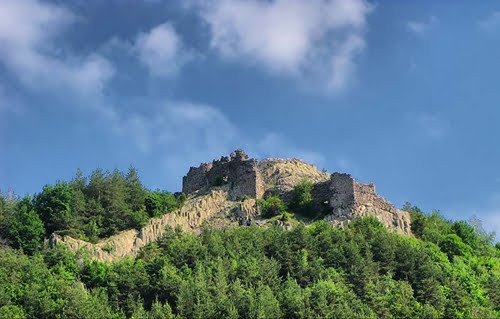
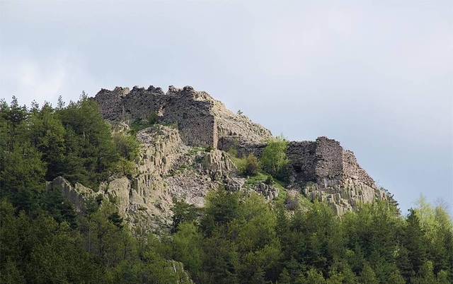
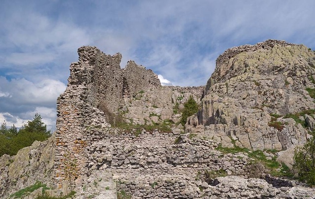
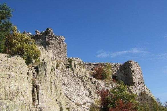
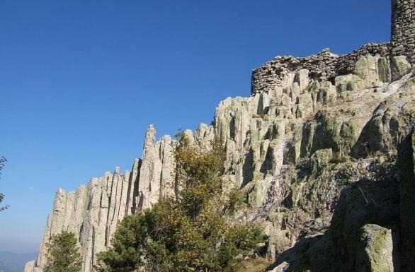
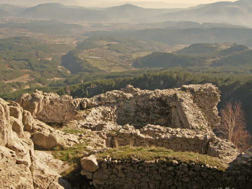
The medievla fortress Ustra is situated on a high peak (1114 m), on a long rocky hill with the same name close to the village of Ustren in the municipality of Dzhebel, Kardzhali Region.
It is located 9 km south-west of Dzhebel, 30 km in the same direction of Kardzhali, 23 km north-east of Zlatograd and about 270 km south-east of the capital Sofia city.
history
The fortress was built in the Middle Ages (X century) in order to protect the trade route that used to pass there and during its existence has mainly been under the control of the Byzantine Empire. According to archaeological data the earliest dating of the fort was from the reign of Constantine VII Porphyrogenitus - (913-959). At that time the Bulgarian Tsar Simeon I most probably took over the fortress, but then ceded it to Byzantium and was proclaimed "vasileopator" - that supreme guardian of the emperor, who married one of his daughters.
The subsequent dissolution of the contract by Zoya - the emperor's mother, soon led to the crippling defeat of the Byzantines at the Battle of Aheloy /917/. However, after Tsar Simeon's death in 927 the fort remained permanently in Byzantine hands despite the secondary evidence that during the Feudalism and the Second Bulgarian Kingdom /XII - XIV century/ it was conquered by Ivan Asen II.
architecture
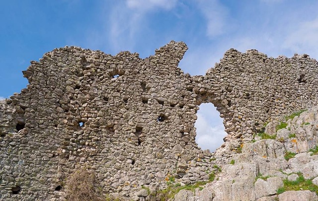
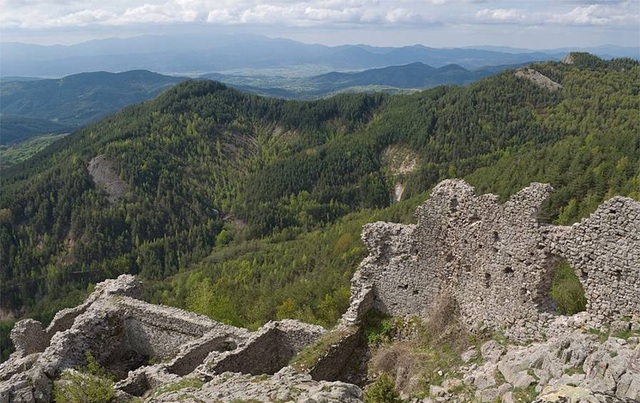
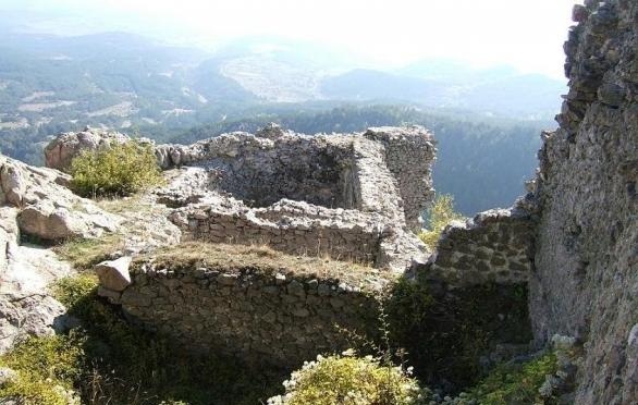
The fortress covers an area of 1.29 ha of which the northern and northwestern part occupied by cliffs. The fortified wall has a U-shape. It is 113 m long. Its thickness at the base is about 3 m, at the top about 2 m and is up to 8 m high. The face of the wall is made of well-cut stones cemented with white mortar, the interior is filled with stones, poured with white mortar. The defense capabilities are reinforced with three towers - one semicircular and two rectangular. They were three-floor. The ground or first floor of the towers was used as a reservoir. Climbing the tower was carried out via internal stone staircase from which parts are preserved in two towers.
The entrance of the fortress was situated in its easternmost part. There are 7 steps, carved into the rock, preserved from it. The foundations of the room that served to house the guardians of the entrance are also preserved. The door was probably vertically moved. In order to enter the fort, one had to walk through the entire area outside the walls and towers.
The first organized excavations were conducted in the period 1971 - 1973, under the leadership of Prof. Stamen Mihaylov. The objects found there show intense life in the period XIII - XIV century. Written evidence of the fort gives George Akropolit in his "Annals" (XIII century). During the archeological excavations numerous metal objects (iron arrows, pieces of a helmet, bronze and silver crosses), pottery, copper coins and more were discovered.
transport
The fort can be reached from the villages of Lebed and Ustren. The road from the village of Lebed is easier to climb but more difficult to find. Should you choose the second road, you have to take the road from the village of Ustren to Zlatograd. At about 4 km you will find the exit where a 2 km long mountain path leading to the fort begins. At about half the distance is the branch for Ustra hut.
accomodation
The hut wearing the same name is situated in the close proximity of the fortress. It is open all-year-round and has 35 places, tourist kitchen and a canteen.
Sources: http://bg.guide-bulgaria.com, http://bg.wikipedia.org, http://www.rhodopes-gallery.com, http://www.bulgariancastles.com
Photos: http://bulgariatravel.org/, http://ivoso.blog.bg

Chuprene Biosphere Reserve
The reserve is one of the largest biosphere reserves in Bulgaria. It is established in 1973 to preserve the northern coniferous forests of Bulgaria. In 1977 it was included in the list of biosphere reserves under the program "Man and Biosphere".
See on the map
Water Holes Cave
Water Holes Cave is located in Apriltsi Municipality, within the Central Balkan National Park on the northern slope of the massif of Botev Mount.
See on the map
Albotin rock monastery
Albotin monastery is an inactive Medieval rock monastery included in Vidin diocese.
See on the map
Uzana - the geographic center of Bulgaria
Uzana - the heart of the Balkans. In its embrace, the mountains has kept this extraordinary place where you can fully take charge with power and hours to enjoy its grandeur and beauty of nature.Far from the urban vanity you will find abundance of colors and shades, serenity and peace of mind. Here the warbling of the birds and the whisper of wild grasslands will put a spell on you forever.

Chervenitsa - geological phenomena over the village of Kunino
The natural phenomenon Chervenitsa is a molded boulder, rising more than 150 m above the terrace of the river Iskar in village of Kunino. It is located about 46 km east of Vratsa and approximately 120 km northeast of Sofia.
See on the map
The museum of salt
A unique museum in the whole Eastern Europe dedicated to the production of salt by solar evaporation of sea water, Pomorie
See on the map
Lopushanski monastery "Sv. Yoan Predtecha"
The Lopushanski monastery is located in the Balkan Mountain in the valley of Dalgodelska Ogosta river. It is operational and consists of a church, residential and farm buildings and a white stone fountain, all surrounded by a stone wall.
See on the map
Taukliman Reserve
Natural Reserve Taukliman typical landslide with length of about 4 km, formed between the edge of the Dobrudzhansko plateau and the coast.

Basilica Sveta Sofia - Sofia city
The Early Christian basilica Sveta Sofia is an active Orthodox church in the center of Sofia city. The church was probably built in the early VI century on the ruins of early Christian tombs from II - IV century and the ruins of two earlier churches from IV-V century. It is located among the necropolis of the ancient Serdica.
See on the map
Medieval fortress "Monyak"
"Monyak" fortress is one of the largest and high located fortresses in the Rhodopes near the village of Shiroko pole, Kardzhali Region
See on the map
Vakarelski monastery "St Petka"
Vakarelski monastery "St Petka" was found in XX century and now it is working occasionally. It was functioning as nunnery.
See on the map
"The Womb" cave
A unique Thracian temple near the village of Nenkovo, Kardzhali Region
See on the map
Thracian sanctuary "Gluhite kamani"
The megalithic complex "Gluhite kamani" is one of the largest Thracian sanctuaries since BC, whose strength continues to act today to anyone who visits it.
See on the map
Krivus Fortress
A medieval fortress located on a picturesque cliff above Arda River near the village of Bashevo, Kardzhali Region
See on the map
"St. Konstantin and Elena" monastery near Ladzha quarter, Ivaylovgrad
The monastery of Lazdha or Ivaylovrad monastery "St. Konstantin and Elena" is situated close to Ladzha quarter in the town of Ivaylovgrad
See on the map
Rakovitsa monastery Sveta Troitsa
Rakovitsa monastery Sveta Troitsa was was found in X-XI century and during the Middle Ages was an important literary and cultural center in Bdin area.
See on the map
Roman tomb - town of Hisarya
The Hisar tomb is a late Roman family tomb built in the second half of the IV-th century.
See on the map
Elenska basilica
Elenska basilica is early Christian temple that is preserved to nowadays and is situated in proximity to the town of Pirdop
See on the map
"St. Theodor Tyron and Theodor Stratilat" church
A unique monument of culture with extremely precious frescoes and icons included in UNESCO's list with the World Cultural Heritage, village of Dobarsko, Blagoevgrad Region
See on the map
Ovech Fortress
One of the oldest fortresses in Bulgaria located on a high mountain plateau above the town of Provadiya
See on the map