Markeli fortress
See on the map


Location
Markeli fortress is located on the territory of Karnobat municipality, about 8 km west of Karnobat town, 50 km northwest of Burgas city, 3 km northwest of the village of Krumovo gradishte and about 308 km east of Sofia city.
Architecture and General Information
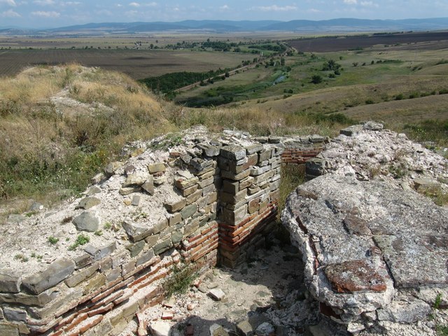
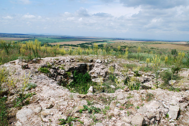
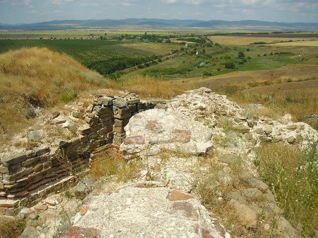
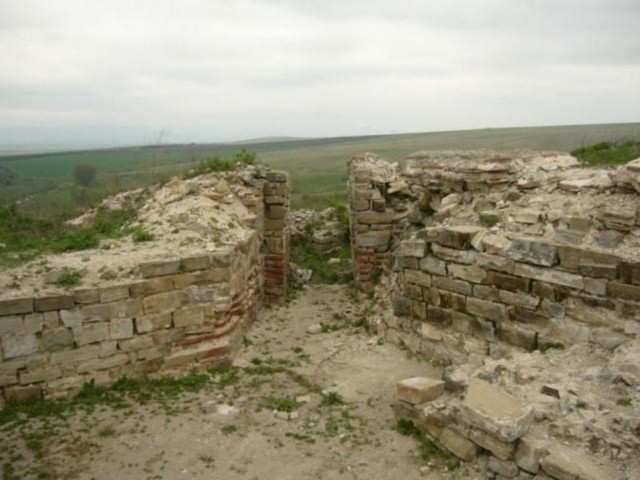
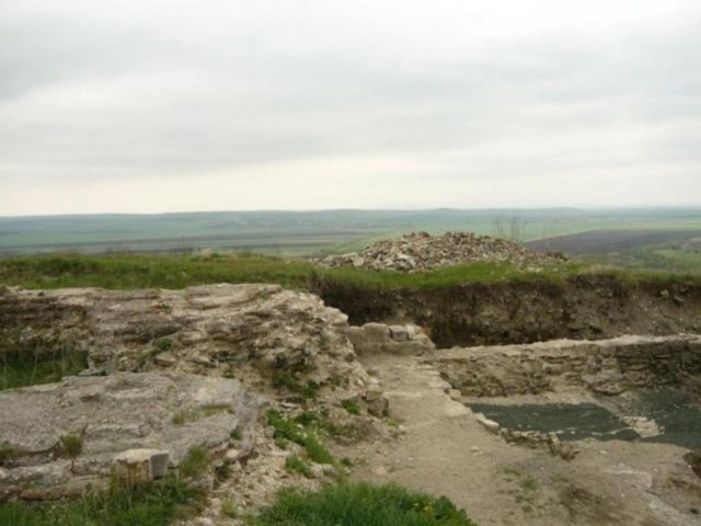
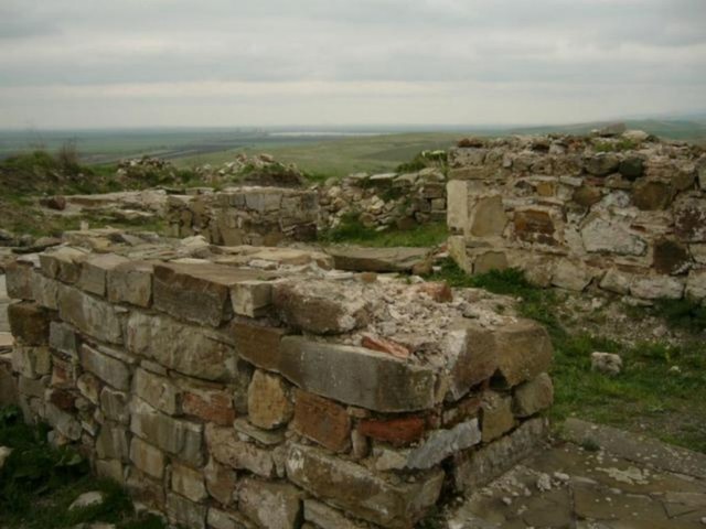
The fortress occupies the western end of Hisar hill, which is a part of the Stara Planina mountain. It covers an area of 4600 acres, and the length of the walls is 530 m. The protective trenches and shafts surrounding the fort as a ring can be seen today. They are one of the largest artificially constructed fortifications found in the Balkan peninsula.
Markeli was unapproachable, and under a siege was supplied with water through a specially constructed water facility, linking the town with the nearby river of Mochuritsa.
The place chosen for the castle was of strategic importance. From the hill where it is located was possible to watch the approaches to the important passages in the Stara Planina mountain - Mokrenski, Varbishki and Rishki and keep a direct eye on a number of fortified villages at the foot of the eastern parts of the Sredna Gora mountain and the Balkan.
The defense of the fortress itself was facilitated by the natural protection of Mochuritsa river and the cliffs to the northwest.
History
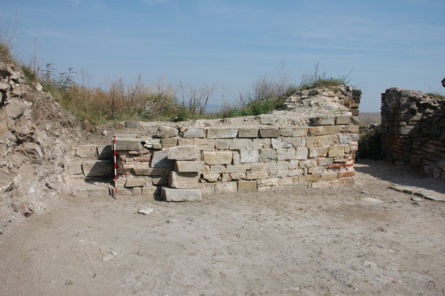
During archaeological excavations in the castle are found remains of a medieval basilica from VI century, an old church from X century, a Byzantine church from XI century and many artifacts such as bronze coins from VI-XIII century, fragments of graphite drawings, ceramic mosaics and medieval bronze stamps.
It is assumed that Markeli was built during the reign of the Byzantine Emperors Anastasius I and Justinian I, to defend the Byzantine territory from enemy attacks. In 756 AD near the frontier fortress fought a battle between the Bulgarian khan Vineh and Constantine V, which the khan lost. In 792 khan Kardam defeated the Byzantine Emperor Constantine VI and Byzantium was obliged to pay a tribute to the Bulgarian state.
From Markeli the Byzantine Emperor Nicephorus I Genik began his march towards the Bulgarian capital Pliska in 811 and was defeated, losing his life. Capturing the fortress in 812 Khan Krum makes it the largest stronghold of the Bulgarians south of the Balkan Mountains. Later the Bulgarian border was moved and Markeli lost its function.
However, as shown by the found coins of the kings Svetoslav Terter and Ivan Alexander, it remains a big Bulgarian fortified town in the late Middle Ages. Markeli was probably destroyed by the Turks in 1371 after the battle of Chernomen and its inhabitants found the town of Karnobat.
Transport
The castle is easily accessible by car from the highway of Trakia and there is a sign to Markeli. A road fork leads to Krumovo Gradishte.
Accommodation
Guests wishing to visit the castle can stay in the city Karnobat that offers hotel rooms.
Sources: http://bg.wikipedia.org; http://www.bulgariainside.com
Photos: http://www.bulgariainside.com

Chuprene Biosphere Reserve
The reserve is one of the largest biosphere reserves in Bulgaria. It is established in 1973 to preserve the northern coniferous forests of Bulgaria. In 1977 it was included in the list of biosphere reserves under the program "Man and Biosphere".
See on the map
Water Holes Cave
Water Holes Cave is located in Apriltsi Municipality, within the Central Balkan National Park on the northern slope of the massif of Botev Mount.
See on the map
Albotin rock monastery
Albotin monastery is an inactive Medieval rock monastery included in Vidin diocese.
See on the map
Uzana - the geographic center of Bulgaria
Uzana - the heart of the Balkans. In its embrace, the mountains has kept this extraordinary place where you can fully take charge with power and hours to enjoy its grandeur and beauty of nature.Far from the urban vanity you will find abundance of colors and shades, serenity and peace of mind. Here the warbling of the birds and the whisper of wild grasslands will put a spell on you forever.

Chervenitsa - geological phenomena over the village of Kunino
The natural phenomenon Chervenitsa is a molded boulder, rising more than 150 m above the terrace of the river Iskar in village of Kunino. It is located about 46 km east of Vratsa and approximately 120 km northeast of Sofia.
See on the map
The museum of salt
A unique museum in the whole Eastern Europe dedicated to the production of salt by solar evaporation of sea water, Pomorie
See on the map
Lopushanski monastery "Sv. Yoan Predtecha"
The Lopushanski monastery is located in the Balkan Mountain in the valley of Dalgodelska Ogosta river. It is operational and consists of a church, residential and farm buildings and a white stone fountain, all surrounded by a stone wall.
See on the map
Taukliman Reserve
Natural Reserve Taukliman typical landslide with length of about 4 km, formed between the edge of the Dobrudzhansko plateau and the coast.

Basilica Sveta Sofia - Sofia city
The Early Christian basilica Sveta Sofia is an active Orthodox church in the center of Sofia city. The church was probably built in the early VI century on the ruins of early Christian tombs from II - IV century and the ruins of two earlier churches from IV-V century. It is located among the necropolis of the ancient Serdica.
See on the map
Medieval fortress "Monyak"
"Monyak" fortress is one of the largest and high located fortresses in the Rhodopes near the village of Shiroko pole, Kardzhali Region
See on the map
Vakarelski monastery "St Petka"
Vakarelski monastery "St Petka" was found in XX century and now it is working occasionally. It was functioning as nunnery.
See on the map
"The Womb" cave
A unique Thracian temple near the village of Nenkovo, Kardzhali Region
See on the map
Thracian sanctuary "Gluhite kamani"
The megalithic complex "Gluhite kamani" is one of the largest Thracian sanctuaries since BC, whose strength continues to act today to anyone who visits it.
See on the map
Krivus Fortress
A medieval fortress located on a picturesque cliff above Arda River near the village of Bashevo, Kardzhali Region
See on the map
"St. Konstantin and Elena" monastery near Ladzha quarter, Ivaylovgrad
The monastery of Lazdha or Ivaylovrad monastery "St. Konstantin and Elena" is situated close to Ladzha quarter in the town of Ivaylovgrad
See on the map
Rakovitsa monastery Sveta Troitsa
Rakovitsa monastery Sveta Troitsa was was found in X-XI century and during the Middle Ages was an important literary and cultural center in Bdin area.
See on the map
Roman tomb - town of Hisarya
The Hisar tomb is a late Roman family tomb built in the second half of the IV-th century.
See on the map
Elenska basilica
Elenska basilica is early Christian temple that is preserved to nowadays and is situated in proximity to the town of Pirdop
See on the map
"St. Theodor Tyron and Theodor Stratilat" church
A unique monument of culture with extremely precious frescoes and icons included in UNESCO's list with the World Cultural Heritage, village of Dobarsko, Blagoevgrad Region
See on the map
Ovech Fortress
One of the oldest fortresses in Bulgaria located on a high mountain plateau above the town of Provadiya
See on the map