Lakatnishkite rocks
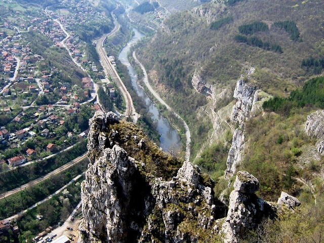
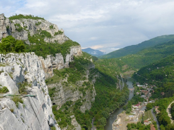

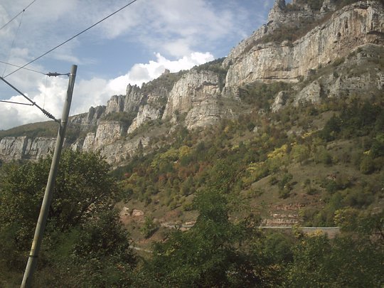
Lakatnishkite rocks are located on the left slope of the Iskar defile in Stara planina mountain. There are situated in Svoge municipality between the rivers of Proboinitsa and Dolo, against the village of Gara Lakatnik.
The Iskar defile is situated on an altitude of about 400 m and just 50 km southwest of Sofia. The name of the rocks like that of the whole area in which there are situated are derived from the name of the turn that Iskar river makes and is with form of bent elbow - in Bulgarian is Lakatnik.
Lakatnishkite rocks are made of red sands and limes and the plasters of the rocks are almost perfectly vertical. The rocks at some places are up to 250 m high above the waters of Iskar river. As a result of the impact on the outer relief powers of the Lakatnishkite rocks there are formed different rock formations like pyramids, towers, cusps etc.
Near the Lakatnishkite rocks is located the karst spring Zhitolub. Around the spring there are small restaurant and artificial lake. Here there are many karst caves. Among them Temnata dupka, Arzhishka dupka, Svinska dupka, Vraza dupka etc.
The rocks are declared natural landmark in 1966 and after 1989 there were also declared for protected area. Also in 1989 the rocks were included in the area of the natural park Vrachanski Balkan.
On the rocks is developed the alpine climbing. These rocks are one of the most visited and popular climbing destinations in the country in Bulgaria.
The extreme beauty and excellent conditions for tourism, climbing and speleology make them attractive for tourists, climbers, explorers and people that like nature. The area is crossing point of many touristic routes.
On the rocks there is built small house one of the symbols of the rocks. In was made in 1938 by the most active climbers in that time Konstantin Svadzhiev, Georgi Tsenev, Georgi Stoimenov and Todor Bozhkov. It is accessible only by rope and is about 300 m above Iskar river. The alpin hut is named Orlovo gnezdo or Eagle's nest.
Another symbol of Lakatnishkite rock is solid monument of stone slabs and was made in honor of the fallen in 1923 September rebels.
In proximity there is 10 meters high iron cross that was constructed in 2001 in memory of the fallen mountain climbers and alpine climbers.
Tourist routes
To the village of Lakatnik you can go by car on the road Sofia - Mezdra through the Iskar defile and also by train. Both times to distance takes about one and a half hour.
There are a couple of ways to go these natural objects one is from the village of Gara Lakatnik and the other is from the village of Milanovo.
In the first case the routes are two - one of them goes after the turnout for Proboinitsa neighborhood and goes to Alpine meadow just to the west end of the hut. The other route starts at the restaurant on the road "Peshterata" and the karst spring Zhitolyub and at its beginning there is a map of the natural park Vrachanski balkan. It also leads to the Alpin meadow. From there to the other routes leads only one path - just go higher. From Milanovo village you can go by car to the monument.
In the area work group of the Mountain Rescue Service.
Sources: bg-tourism.com, bgizlet.com, bg.wikipedia.org
Photos: Mirela, Internet

Chuprene Biosphere Reserve
The reserve is one of the largest biosphere reserves in Bulgaria. It is established in 1973 to preserve the northern coniferous forests of Bulgaria. In 1977 it was included in the list of biosphere reserves under the program "Man and Biosphere".
See on the map
Water Holes Cave
Water Holes Cave is located in Apriltsi Municipality, within the Central Balkan National Park on the northern slope of the massif of Botev Mount.
See on the map
Albotin rock monastery
Albotin monastery is an inactive Medieval rock monastery included in Vidin diocese.
See on the map
Uzana - the geographic center of Bulgaria
Uzana - the heart of the Balkans. In its embrace, the mountains has kept this extraordinary place where you can fully take charge with power and hours to enjoy its grandeur and beauty of nature.Far from the urban vanity you will find abundance of colors and shades, serenity and peace of mind. Here the warbling of the birds and the whisper of wild grasslands will put a spell on you forever.

Chervenitsa - geological phenomena over the village of Kunino
The natural phenomenon Chervenitsa is a molded boulder, rising more than 150 m above the terrace of the river Iskar in village of Kunino. It is located about 46 km east of Vratsa and approximately 120 km northeast of Sofia.
See on the map
The museum of salt
A unique museum in the whole Eastern Europe dedicated to the production of salt by solar evaporation of sea water, Pomorie
See on the map
Lopushanski monastery "Sv. Yoan Predtecha"
The Lopushanski monastery is located in the Balkan Mountain in the valley of Dalgodelska Ogosta river. It is operational and consists of a church, residential and farm buildings and a white stone fountain, all surrounded by a stone wall.
See on the map
Taukliman Reserve
Natural Reserve Taukliman typical landslide with length of about 4 km, formed between the edge of the Dobrudzhansko plateau and the coast.

Basilica Sveta Sofia - Sofia city
The Early Christian basilica Sveta Sofia is an active Orthodox church in the center of Sofia city. The church was probably built in the early VI century on the ruins of early Christian tombs from II - IV century and the ruins of two earlier churches from IV-V century. It is located among the necropolis of the ancient Serdica.
See on the map
Medieval fortress "Monyak"
"Monyak" fortress is one of the largest and high located fortresses in the Rhodopes near the village of Shiroko pole, Kardzhali Region
See on the map
Vakarelski monastery "St Petka"
Vakarelski monastery "St Petka" was found in XX century and now it is working occasionally. It was functioning as nunnery.
See on the map
"The Womb" cave
A unique Thracian temple near the village of Nenkovo, Kardzhali Region
See on the map
Thracian sanctuary "Gluhite kamani"
The megalithic complex "Gluhite kamani" is one of the largest Thracian sanctuaries since BC, whose strength continues to act today to anyone who visits it.
See on the map
Krivus Fortress
A medieval fortress located on a picturesque cliff above Arda River near the village of Bashevo, Kardzhali Region
See on the map
"St. Konstantin and Elena" monastery near Ladzha quarter, Ivaylovgrad
The monastery of Lazdha or Ivaylovrad monastery "St. Konstantin and Elena" is situated close to Ladzha quarter in the town of Ivaylovgrad
See on the map
Rakovitsa monastery Sveta Troitsa
Rakovitsa monastery Sveta Troitsa was was found in X-XI century and during the Middle Ages was an important literary and cultural center in Bdin area.
See on the map
Roman tomb - town of Hisarya
The Hisar tomb is a late Roman family tomb built in the second half of the IV-th century.
See on the map
Elenska basilica
Elenska basilica is early Christian temple that is preserved to nowadays and is situated in proximity to the town of Pirdop
See on the map
"St. Theodor Tyron and Theodor Stratilat" church
A unique monument of culture with extremely precious frescoes and icons included in UNESCO's list with the World Cultural Heritage, village of Dobarsko, Blagoevgrad Region
See on the map
Ovech Fortress
One of the oldest fortresses in Bulgaria located on a high mountain plateau above the town of Provadiya
See on the map