Kabile Archaeology Reserve

Location
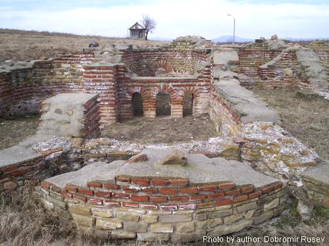
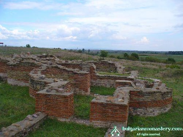
The Kabile National Archaeology Reserve is situated 6 km north of the town of Yambol. It preserves the ruins of the most significant antique Thracian town of Kabile. This economic, political and cultural centre of Ancient Thrace has been investigated for more than 25 years. The remains are really impressive. There is an archaeological museum as well. Working hours: summer time - 8.00 a.m. - 8.00 p.m., winter time - 10.00 a.m. - 4.00 p.m. A bus runs from Yambol to the museum 9 times a day.
History
The Thracian royal city of Cabyle is located on a plateau, crowned with a stone acropolis, which is a sanctuary-observatory. According to some observations, the following things have been discovered there: a rock-cut "Cybela relief", the foundations of a public building, and two rectangular chambers having most likely a cult-related character.
The name of the habitat originates from Cybela. A later toponym of the habitat is Dampolis/Diampolis as a corruption of Diospolis. Fol, 1994: 219-224 states the hypothesis that Diospolis, i. e., "Zeus's city", is a translation-description of the honoring of a supreme male god, most likely Sabasius. Partially, the reason for this hypothesis is the possible etymology Kab-/Sab- in the root of Cabyle's name.
The second part of the toponym 'yle gives the opportunity for using "sacred forest", i. e., Cabyle's name to depict "Sabo's (belonging to Sabasius) holy forest". This interpretation is supported by the rock-cut monument on the top which functioned during the 2-1 mil. BC.
The place of residence originated around the sanctuary at the end of the 2 mil. BC. The plateau is located at the rover Tundzha"s turn south towards Edirne (today's Turkey), and dominates over the plain. The ceramics discovered from 10-6 c. BC proves that the place of residence existed during the early Iron Age as well.
Cabyle was a key place on the way from Aenos (today's Enes), next to Maritza river's mouth (ancient Hebros), to Hemus (Stara Planina) and the lower course of the Danube river. Cabyle was also important if one was traveling diagonally from Byzantium through Serdika (Sofia) - Naissos (Nish) towards the middle course of the Danube river .
This location predetermined the destiny of the place of residence for centuries to come. The archaeological material shows that during 5-4 c. BC the city maintained important trade relationships with the Hellenic cities at the Aegean and Black sea coasts.

Chuprene Biosphere Reserve
The reserve is one of the largest biosphere reserves in Bulgaria. It is established in 1973 to preserve the northern coniferous forests of Bulgaria. In 1977 it was included in the list of biosphere reserves under the program "Man and Biosphere".
See on the map
Water Holes Cave
Water Holes Cave is located in Apriltsi Municipality, within the Central Balkan National Park on the northern slope of the massif of Botev Mount.
See on the map
Albotin rock monastery
Albotin monastery is an inactive Medieval rock monastery included in Vidin diocese.
See on the map
Uzana - the geographic center of Bulgaria
Uzana - the heart of the Balkans. In its embrace, the mountains has kept this extraordinary place where you can fully take charge with power and hours to enjoy its grandeur and beauty of nature.Far from the urban vanity you will find abundance of colors and shades, serenity and peace of mind. Here the warbling of the birds and the whisper of wild grasslands will put a spell on you forever.

Chervenitsa - geological phenomena over the village of Kunino
The natural phenomenon Chervenitsa is a molded boulder, rising more than 150 m above the terrace of the river Iskar in village of Kunino. It is located about 46 km east of Vratsa and approximately 120 km northeast of Sofia.
See on the map
The museum of salt
A unique museum in the whole Eastern Europe dedicated to the production of salt by solar evaporation of sea water, Pomorie
See on the map
Lopushanski monastery "Sv. Yoan Predtecha"
The Lopushanski monastery is located in the Balkan Mountain in the valley of Dalgodelska Ogosta river. It is operational and consists of a church, residential and farm buildings and a white stone fountain, all surrounded by a stone wall.
See on the map
Taukliman Reserve
Natural Reserve Taukliman typical landslide with length of about 4 km, formed between the edge of the Dobrudzhansko plateau and the coast.

Basilica Sveta Sofia - Sofia city
The Early Christian basilica Sveta Sofia is an active Orthodox church in the center of Sofia city. The church was probably built in the early VI century on the ruins of early Christian tombs from II - IV century and the ruins of two earlier churches from IV-V century. It is located among the necropolis of the ancient Serdica.
See on the map
Medieval fortress "Monyak"
"Monyak" fortress is one of the largest and high located fortresses in the Rhodopes near the village of Shiroko pole, Kardzhali Region
See on the map
Vakarelski monastery "St Petka"
Vakarelski monastery "St Petka" was found in XX century and now it is working occasionally. It was functioning as nunnery.
See on the map
"The Womb" cave
A unique Thracian temple near the village of Nenkovo, Kardzhali Region
See on the map
Thracian sanctuary "Gluhite kamani"
The megalithic complex "Gluhite kamani" is one of the largest Thracian sanctuaries since BC, whose strength continues to act today to anyone who visits it.
See on the map
Krivus Fortress
A medieval fortress located on a picturesque cliff above Arda River near the village of Bashevo, Kardzhali Region
See on the map
"St. Konstantin and Elena" monastery near Ladzha quarter, Ivaylovgrad
The monastery of Lazdha or Ivaylovrad monastery "St. Konstantin and Elena" is situated close to Ladzha quarter in the town of Ivaylovgrad
See on the map
Rakovitsa monastery Sveta Troitsa
Rakovitsa monastery Sveta Troitsa was was found in X-XI century and during the Middle Ages was an important literary and cultural center in Bdin area.
See on the map
Roman tomb - town of Hisarya
The Hisar tomb is a late Roman family tomb built in the second half of the IV-th century.
See on the map
Elenska basilica
Elenska basilica is early Christian temple that is preserved to nowadays and is situated in proximity to the town of Pirdop
See on the map
"St. Theodor Tyron and Theodor Stratilat" church
A unique monument of culture with extremely precious frescoes and icons included in UNESCO's list with the World Cultural Heritage, village of Dobarsko, Blagoevgrad Region
See on the map
Ovech Fortress
One of the oldest fortresses in Bulgaria located on a high mountain plateau above the town of Provadiya
See on the map