Durankulak Lake
See on the map
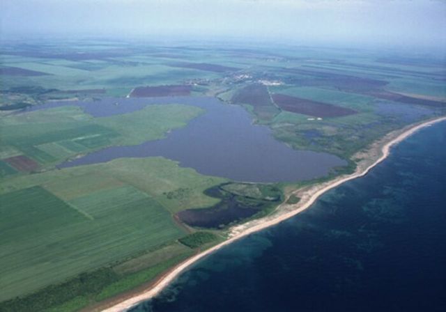


Durankoulak lake is a protected area in Northeastern Bulgaria. It is located near the village of Durankulak, about 5 km from the border between Bulgaria and Romania, about 15 km north of Shabla town and approximately 530 km northeast of Sofia city.
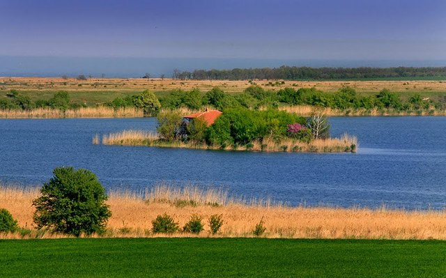
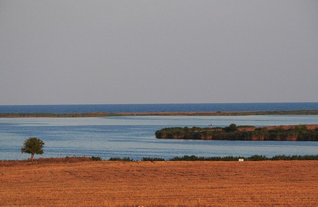
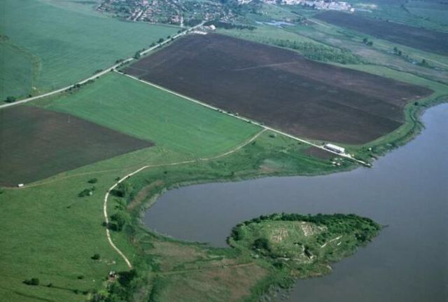
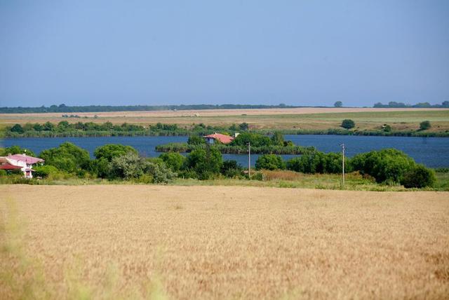
Is a coastal lake, estuary type with an area of 4037 dka. To the east is separated from the sea by a narrow strip of natural sand dunes and connects to it via a canal. In the western part of the lake are two islands (respectively 20 and 5.3 dka).
NATURE
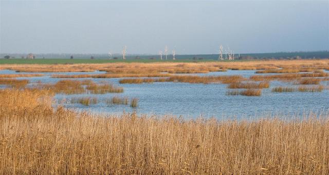
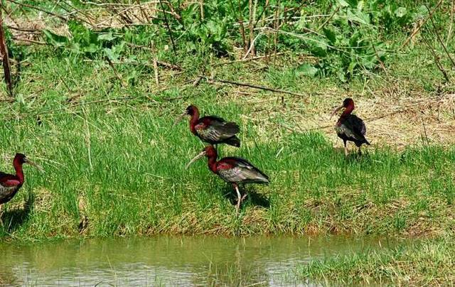
Durankoulak Lake is one of the best preserved coastal wetlands in Bulgaria with international importance for the conservation of more than 260 species of rare and endangered plants and animals. The region hosts 5 endemic plants of the Balkan Peninsula. The deposit of Trirabest kamash is the most representative for Bulgaria.
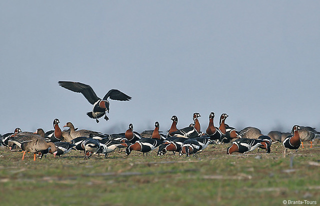
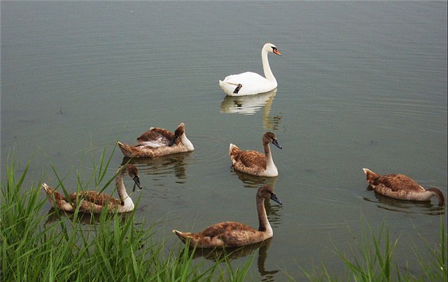
Located on the migration route Via Pontica the wetland provides favorable conditions for feeding and resting of many species of migratory birds. The lake is a shelter for the Little Bittern, Ferruginous Duck, Mute Swan, Little Cormorant, White Pelican, Indian Warbler. The surrounding loose shores nest the extremely beautiful with its colorful plumage Bee-eater. Along with the Shabla Lake give shelter in the winter season to the White-fronted Goose and 80-90% of the world population of Red-breasted Goose.
HISTORY
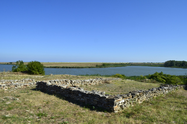
On the western shore of Duranculak Lake were discovered dugouts by the first farmers of Dobrudzha (5100 - 4700 BC), also burial mounds of Proto Bronze era (3500 - 3400 BC) and a late ancient Sarmatian necropolis. There are cemeteries left by people who had inhabited the Big Island in the lake.
The explored over 12 000 prehistoric burials indicate that western shores of the Black Sea was a cradle of the most ancient civilization of humanity. On the Big Island of the lake there is a Eneolithic mound (4600 - 4200 BC) which is a cultural monument of national importance. On the south side of the island there is a fortified settlement from Late Bronze and early Iron Age (1300 - 1200 BC).
26 m inside the massif of the island is cut a Hellenistic cave temple of the goddess Cybele (3rd century BC) and over the whole island was situated a fortified Proto Bulgarian settlement from 9-10 century. Part of it is exhibited.
TRANSPORT
The lake can be reached by car along the international road E87. Before getting to Durankulak village there is a turnoff for the Archaeological excavation of the big island. You can also take a bus to the village and then walk to the lake.
ACCOMMODATION
You can rent a room in the guest house in Durankoulak or in the house for watching birds on the lake.
For those who want to enjoy the tranquility and the beautiful beach there are 30 bungalows set in a small grove on the beach. Each bungalow consists of a room with three beds, en-suite bathroom / WC and small balcony. Camping guests enjoy a playground, a parking lot, a soccer field and volleyball on the beach. In the camp there is a large restaurant and a beach bar.
Sources:http://shabla.be, http://bg.wikipedia.org, Mirela
Photos:http://www.panoramio.com, http://shabla.be, http://infobg.net, Internet.

Chuprene Biosphere Reserve
The reserve is one of the largest biosphere reserves in Bulgaria. It is established in 1973 to preserve the northern coniferous forests of Bulgaria. In 1977 it was included in the list of biosphere reserves under the program "Man and Biosphere".
See on the map
Water Holes Cave
Water Holes Cave is located in Apriltsi Municipality, within the Central Balkan National Park on the northern slope of the massif of Botev Mount.
See on the map
Albotin rock monastery
Albotin monastery is an inactive Medieval rock monastery included in Vidin diocese.
See on the map
Uzana - the geographic center of Bulgaria
Uzana - the heart of the Balkans. In its embrace, the mountains has kept this extraordinary place where you can fully take charge with power and hours to enjoy its grandeur and beauty of nature.Far from the urban vanity you will find abundance of colors and shades, serenity and peace of mind. Here the warbling of the birds and the whisper of wild grasslands will put a spell on you forever.

Chervenitsa - geological phenomena over the village of Kunino
The natural phenomenon Chervenitsa is a molded boulder, rising more than 150 m above the terrace of the river Iskar in village of Kunino. It is located about 46 km east of Vratsa and approximately 120 km northeast of Sofia.
See on the map
The museum of salt
A unique museum in the whole Eastern Europe dedicated to the production of salt by solar evaporation of sea water, Pomorie
See on the map
Lopushanski monastery "Sv. Yoan Predtecha"
The Lopushanski monastery is located in the Balkan Mountain in the valley of Dalgodelska Ogosta river. It is operational and consists of a church, residential and farm buildings and a white stone fountain, all surrounded by a stone wall.
See on the map
Taukliman Reserve
Natural Reserve Taukliman typical landslide with length of about 4 km, formed between the edge of the Dobrudzhansko plateau and the coast.

Basilica Sveta Sofia - Sofia city
The Early Christian basilica Sveta Sofia is an active Orthodox church in the center of Sofia city. The church was probably built in the early VI century on the ruins of early Christian tombs from II - IV century and the ruins of two earlier churches from IV-V century. It is located among the necropolis of the ancient Serdica.
See on the map
Medieval fortress "Monyak"
"Monyak" fortress is one of the largest and high located fortresses in the Rhodopes near the village of Shiroko pole, Kardzhali Region
See on the map
Vakarelski monastery "St Petka"
Vakarelski monastery "St Petka" was found in XX century and now it is working occasionally. It was functioning as nunnery.
See on the map
"The Womb" cave
A unique Thracian temple near the village of Nenkovo, Kardzhali Region
See on the map
Thracian sanctuary "Gluhite kamani"
The megalithic complex "Gluhite kamani" is one of the largest Thracian sanctuaries since BC, whose strength continues to act today to anyone who visits it.
See on the map
Krivus Fortress
A medieval fortress located on a picturesque cliff above Arda River near the village of Bashevo, Kardzhali Region
See on the map
"St. Konstantin and Elena" monastery near Ladzha quarter, Ivaylovgrad
The monastery of Lazdha or Ivaylovrad monastery "St. Konstantin and Elena" is situated close to Ladzha quarter in the town of Ivaylovgrad
See on the map
Rakovitsa monastery Sveta Troitsa
Rakovitsa monastery Sveta Troitsa was was found in X-XI century and during the Middle Ages was an important literary and cultural center in Bdin area.
See on the map
Roman tomb - town of Hisarya
The Hisar tomb is a late Roman family tomb built in the second half of the IV-th century.
See on the map
Elenska basilica
Elenska basilica is early Christian temple that is preserved to nowadays and is situated in proximity to the town of Pirdop
See on the map
"St. Theodor Tyron and Theodor Stratilat" church
A unique monument of culture with extremely precious frescoes and icons included in UNESCO's list with the World Cultural Heritage, village of Dobarsko, Blagoevgrad Region
See on the map
Ovech Fortress
One of the oldest fortresses in Bulgaria located on a high mountain plateau above the town of Provadiya
See on the map